HMI: Matters for Discussion

Background notes

1 Ten Good Schools
2 Classics in Comprehensive Schools
3 Modern Languages in Comprehensive Schools
4 Gifted Children in Middle and Comprehensive Secondary Schools
5 The Teaching of Ideas in Geography
6 Mixed Ability Work in Comprehensive Schools
7 The Education of Children in Hospitals for the Mentally Handicapped
8 Developments in the BEd Degree Course
9 Mathematics 5 to 11
10 Community Homes with Education
11 A View of the Curriculum
12 Modern Languages in Further Education
13 Girls and Science
14 Mathematics in the Sixth Form
15 The New Teacher in School

The Teaching of Ideas in Geography

The complete document is presented in this single web page. You can scroll through it or use the following links to go straight to the various sections:

1 Introduction (page 1)
2 Ideas in Geography (5)
3 Generalisations (15)
4 Use of generalisations (41)
Appendix: Mapwork (57)

The text of The Teaching of Ideas in Geography was prepared by Derek Gillard and upoaded on 16 Aug 2011.


The Teaching of Ideas in Geography
HMI Series: Matters for Discussion No. 5

London: Her Majesty's Stationery Office 1978
© Crown copyright material is reproduced with the permission of the Controller of HMSO and the Queen's Printer for Scotland.


[title page]

Department of Education and Science

HMI Series: Matters for Discussion 5


The Teaching of Ideas
in Geography

Some Suggestions for the Middle and
Secondary Years of Education

A discussion paper by some members of
HM Inspectorate of Schools


London: Her Majesty's Stationery Office


[page ii]


The publications in this series are intended to stimulate professional discussion. They are based on HM Inspectors' observation of work in educational institutions and present their thoughts on some of the issues involved. The views expressed are those of the authors and are not necessarily those of the Inspectorate as a whole or of the Department of Education and Science. It is hoped that they will promote debate at all levels so that they can be given due weight when educational developments are being assessed or planned. Nothing said is to be construed as implying Government commitment to the provision of additional resources.

HM Inspectorate of Schools wishes to thank the members of University Departments of Geography and Education who generously commented on the generalisations at the draft stage; it also acknowledges the help given by the schools and the teachers' group who have allowed parts of their syllabuses to be used as illustrations.


© Crown copyright 1978
First published 1978

ISBN 0 11 270445 X


[page iii]

Contents

Preface
v

1 Introduction
1

2 Ideas in Geography
5
Concepts5
Generalisations6
Models and systems7
Decision-making and perception9
Skills10
Attitudes10
Progression11

3 Generalisations
15
Farming15
Landforms18
Manufacturing industries19
Natural resources22
Population23
Recreation25
Settlement29
Soils and vegetation30
Towns and cities33
Transport35
Weather and climate38

4 Use of generalisations
41
In the classroom41
Syllabus construction45
Some examples of syllabuses49

Appendix Mapwork
57


[page v]

Preface


At all stages of education in schools in England and Wales there seems to be acceptance - often explicit, sometimes implicit - in what the schools do, of the need to help pupils make sense of the varied and occasionally confusing world in which they live. One of the major needs for schools is to ensure that their pupils are given the opportunity to acquire a range of skills, interests, knowledge and understanding upon which they can build and develop their lives as adult members of society.

This booklet confines itself to considering some of the ways in which the study of geography can contribute effectively towards this end, and is directed primarily to specialist and non-specialist teachers of the subject in schools. It arises, in part, from the observations of specialist geography HMI during visits to schools, but more particularly from the need for such a publication frequently expressed by teachers from all stages of education during discussions and conversations in schools, on in-service training courses and at meetings of the professional subject associations.

The publications in this series are intended to stimulate professional discussion. They are based on HM Inspectors' observation of work in educational institutions and present their thoughts on some of the issues involved. The views expressed are those of the authors and are not necessarily those of the Inspectorate as a whole or of the Department of Education and Science. It is hoped that they will promote debate at all levels so that they can be given due weight when educational developments are being assessed or planned.

Nothing said is to be construed as implying Government commitment to the provision of additional resources.


[page 1]

1 Introduction


The geographical information available to the teacher is almost unlimited and, in many respects, soon dated. The need for pupils to acquire a relevant selection of factual information about places is clear, but the case for including geography (or its content, ideas and way of working) in the curriculum rests on its ability to help pupils identify and explain recurrent physical and human spatial patterns, the processes which work to create these patterns and the complex factors which link places together. Such studies can lead to a concern with social issues and problems such as those of the inner areas of large cities, or the siting of activities which may have environmental or social implications, to a better understanding of industrial and commercial requirements and to an interest in the ways in which decisions affecting the community are made. For example, an understanding of the development of motorways in Britain involves knowledge of the distribution of the major concentrations of population and industry and of the associated movements of people and goods, knowledge of the characteristics of networks, an awareness of the planning and decision-making processes at local and national levels, and some appreciation of the technological, economic and political factors involved. Depth of knowledge and understanding of these aspects is likely to be cumulative over a considerable period rather than to result from a short course of study; inevitably, too, the eventual level of understanding and knowledge gained by each pupil will vary considerably.

Factual information is certainly required, but understanding presupposes the development of appropriate concepts and generalisations. For instance, in the example quoted above, a concept of fundamental importance is that of 'relative-location'; the construction of a motorway effectively alters the relative location of the places which it serves. An illustration of this is the way in which the building of the M4 between London and Cardiff reduced the distance and/or travelling time by road not merely between the terminal points but also between many towns with access to the motorway. The combination of change of distance/travelling time and of degree of accessibility has altered the relative locations of the towns, with consequent effects upon the patterns of movement of people and goods between them.

There is growing evidence that many teachers and others are aware that the identification of such concepts and generalisations provides the basis for understanding, and that they are considering the implications of this approach for the design of geography courses. Some teachers, working alone or in groups, are attempting to identify the ideas that will be most useful for their pupils, to decide the level of understanding that is appropriate and to plan courses that allow for progression in keeping with their pupils' capabilities, experience and developing intellectual abilities.


[page 2]

In Chapter 3 of this publication an attempt is made to state some generalisations which it is thought will assist teachers in the design of their courses. The generalisations are divided into a number of sections which reflect the conventional subdivisions of geography into the systematic studies most frequently used in schools; this categorisation has been adopted purely for convenience and ease of reference. It is not suggested that the categories used are exhaustive; similar lists of ideas could be prepared for other areas of the subject, political geography or historical geography, for example; nor are the lists themselves intended to be comprehensive. They are presented as examples of ideas in some areas of the subject which can be explored with pupils up to the age of 16 years. The ideas do not represent any attempt at an authoritative statement of what should be taught in schools, and therefore, by omission, what should not be taught. Moreover, it should not be assumed that the basically 'systematic' grouping of the generalisations implies a recommendation of a 'systematic' approach to syllabus construction; indeed it is to be hoped that an appropriate selection of generalisations will also contribute much to thematic and area studies in geography.

Methods of teaching geography in schools vary widely and it is expected that the ways in which these suggestions are used will vary equally widely. Those teachers working within a framework of systematic categories (studies of industry, transport, settlement, etc), a method gaining in popularity, will probably wish to select ideas around which their courses can be organised and will study areas chosen from different parts of the world to illustrate the generalisations. Large numbers of pupils, however, continue to be taught geography within some kind of regional or area context while others have their geographical education as part of some form of interdisciplinary or multi-disciplinary studies. In the former case the teacher may select a particular area for study because it provides a suitable illustration of important general ideas. If other criteria determine the choice of area to be studied, the process will be reversed and the relevant ideas will be selected from those which are seen to be appropriate to the subject matter. If the teacher has chosen to investigate a theme in an interdisciplinary or multidisciplinary way it is still possible to select from the lists a number of generalisations appropriate to the geographical aspects of the study and ensure that these, with others identified as necessary by the teacher, are incorporated in the pupils' learning. In such ways it is possible to ensure that the fundamental ideas on which geography is based are common to all modes of working. Some approaches more than others may help to maintain continuity of ideas, and progression in them, both matters of prime importance to teachers in their planning and to pupils in their learning.

The purpose of the generalisations is to help explain the processes and patterns of the real world, but each can deal only with limited aspects of a complex and varied whole. Pupils at different stages of a school course will study different material which will nevertheless often exemplify many of the same generalisations. The range and complexity of the material studied by pupils within a year group, however they may be organised, can be adjusted to allow a depth of study appropriate to the pupils' varying abilities. With the more


[page 3]

advanced pupil, the depth of study and interpretation will inevitably be more complex and more demanding on the pupil's ability to understand and develop the ideas further.

Chapter 2 examines in more detail the structure underlying the term, 'Ideas in Geography'; Chapter 3 includes a number of generalisations grouped according to systematic categories; Chapter 4 examines some of the ways in which the use of generalisations can influence work in the classroom and concludes with examples of the contrasting ways in which a number of schools and a teachers' group have used generalisations as a basis for planning their syllabuses. The use of maps is so fundamental to geography teaching that any discussion of work in the classroom would be incomplete without reference to this basic need, and the appendix offers some suggestions of the map skills which pupils should acquire to enable them to use maps effectively during the course of their wider geographical studies.


[page 5]

2 Ideas in geography


In Chapter 1 it was argued that a pupil's understanding can be firmly based only if the concepts and generalisations appropriate to a particular study have been developed. In this section more detailed attention is given to the nature of concepts, generalisations and models and systems, all of which can be covered by the umbrella term 'idea'.

Concepts

Geographical understanding does not begin with geography lessons, any more than concept learning must await attendance at school. Most children in this country are exposed to a wealth of information about the world in which they live. Relevant experience is obtained at home, in the local area, on journeys further afield and from indirect sources, such as books and television. However, the mere accumulation of a store of discrete bits of information will not lead very far. The process of learning depends upon the individual being able to reflect on previous experiences and generalise from them. Later in a new, but similar, situation the generalisation can be used to identify what is significant and interpret what is perceived. Thus children who frequently accompany their parents shopping are soon able to develop some notion of what a shop is while at the same time learning to distinguish between different types of shops. In a similar way, with appropriate experience, they will learn to identify other features of the landscape - factories, schools, railways, parks, woods, rivers, beaches. Their knowledge about each may be slight, but they become sufficiently aware of characteristics to recognise an example as belonging to a particular category, and, having recognised the type, they may anticipate other attributes not immediately evident. The sight of a railway brings an expectation of trains, the mention of a park reminds them of swings. In time they develop a clearer and fuller concept of what these features are and what distinguishes them from other features that are not of the same category. Without such conceptual development there would be no significant application of learning to other situations.

In their early years children develop some knowledge, however rudimentary, about a vast range of objects and activities that come within their direct personal experience, and they learn to attach appropriate labels to them. It is much more difficult for them to develop a concept of some object or process of which they have no direct experience or which they cannot easily observe in its entirety. Thus the idea of a glacier, a river basin, a tropical plantation, or the process of migration will be difficult for younger pupils to grasp. Many of the concepts used regularly by geographers relate to extremely complex features and understanding their essential nature involves a high level of abstraction. This is easily forgotten when the label that identifies the concept is part of our everyday language, as in the case of 'climate' and 'city'. Pupils can use terms, sometimes


[page 6]

even in correct contexts, without having much understanding of the concept to which the term refers. But the introduction of an appropriate label at a suitable time helps the pupil to focus on the particular idea and talk about it. Adults and children rely heavily on language to clarify thoughts, exchange ideas and so develop shared understanding.

In a discipline the fundamental concepts which structure its thinking, and have wide application, are inevitably abstract ideas. In geography they include spatial concepts, such as 'distribution pattern', 'distance', 'accessibility', and also ecological ideas, such as 'environment' and 'resource', reflecting the geographer's interest in location and the complex relationships between man, his culture and his biophysical environment. Accessibility may be taken as an example of an important spatial concept, equally applicable to the study of a new communication network, the location of factories, the influence of ease of access to markets on farmers' choice of products, the suitability of alternative locations for settlement and the relative attraction within a town of different residential areas. The idea may be introduced in a simple way and within a familiar context (eg the ease of getting to a football ground from the various parts of a town), but it can be developed into a more sophisticated idea to be applied to more complex situations. Access may be required to a variety of facilities (eg the factory requires access to materials, labour and markets) and the ease of access may be measured in a variety of ways (eg distance, time, cost). A concept such as accessibility can therefore be approached at different levels of understanding. To say that an individual has studied 'glaciers' or 'cities' or 'accessibility' is to give no indication of the many possible aspects that have been tackled or of what depth of knowledge has been acquired. The most important concepts should be returned to, re-examined and extended many times during a course of study.

Generalisations

In seeking to explain spatial patterns, geographers are concerned to identify recurrent relationships. These can be expressed as statements in the form of a rule or principle that specifies a relationship between concepts. Thus the statement 'the central business district occupies that part of a city which is most generally accessible to the people living within the city and within the city's sphere of influence' describes the general location of central business districts in terms of 'accessibility', 'city' and 'sphere of influence'. It is a fairly precise statement in that it specifies a particular relationship, but it demands considerable knowledge because to make sense of the generalisation one has to understand the meaning of the constituent concepts, several of which are abstract ideas. However, generalisations, like concepts, can be approached at different levels of understanding. The relationship between transport and locational specialisation may be expressed in a general statement that 'adequate transport systems permit specialisation of activities in suitable localities'. To have some notion of the idea even at a simple level requires an appreciation of the advantages of specialisation and the nature of the links which tie the localities where activities are concentrated to the wider areas which they serve or from which they are supplied. In a rural area, this idea could be introduced through pupils investi-


[page 7]

gating the catchment area of their own school and the journeys to and from school. The relationship between the size of the school, the size and the nature of the catchment area and the transport system involved could be understood in terms of a specific case about which they had direct experience. Later, the idea might be extended to other activities, such as farming and manufacturing industry, and the factors involved analysed. Eventually some pupils would be able to discuss and evaluate the generalisation as an abstract idea and to apply it to a wide range of situations.

Because of the complex nature of the subject matter of geography and the central role of man as a decision-maker exploiting and modifying his own environment (referred to in more detail on page 9), it is hardly surprising that many geographical generalisations are 'weak statements' compared with the laws of physical science. The relationship that is identified is often complicated by other factors and usually involves a general tendency or high probability rather than a simple, constant principle. This does not mean that the relationship is unimportant. For a pupil to understand such a relationship, however, he must be given the opportunity to see how it functions in different situations, and the teacher has a vital role to play in selecting relevant information, posing appropriate questions and helping pupils develop and refine their ideas. This assumes, of course, that the teacher already knows which ideas will be most valuable for his pupils and has sufficient awareness of the structure of geography to be able to introduce and exploit a significant idea when the opportunity arises. A good deal of recently published material in geography has introduced general ideas in a helpful and explicit way.

Models and systems

Ideas may be brought together in more elaborate conceptual structures, such as models. The term 'model' is used in a variety of ways, but here it is taken to mean a simplified representation of reality, an attempt to illustrate a structure which links relationships and inter-relationships in a particular context. As such, models do not reveal all the details of a situation but focus on those aspects which are most significant. They involve a degree of abstraction, since only by setting aside some detail are we able to identify significant patterns and so make some sense of the complexities of the real world. Models have been part of geographical work for a long time. A particular example, made familiar through televised weather forecasts, is the Bjerknes weather model of frontal depressions which illustrates the way in which sense may be brought to a confusing array of observations of temperature, humidity, precipitation, wind direction and speeds, and which through its general applicability may lead to prediction. Simple models relating, for example, industrial location to single factors, may be developed by teachers to meet their pupils' needs. Later, the interaction of several factors can be introduced through the study of more complex models, such as the 'Weber' model of industrial development. Recently published geography books show a variety of models simplified for classroom use.

The workings of the real world may be interpreted in terms of 'systems', each of which is seen as a coherent unit with components which are functionally related. Emphasis is placed upon the links


[page 8]

between the parts; on flows of energy, materials and information within the system, and on ways in which the system responds to various processes. In geography the study of the locational or spatial attributes of systems may vary in scale from the functioning of an individual farm or residential neighbourhood to that of a complex economic or social system at a national or even international level. Geographical systems are not isolated from outside influences. They are therefore termed 'open systems' and the inputs and outputs can be identified and related to the functioning of the system. The manner in which a farm functions illustrates well the idea of an open system. Inputs (which may be daily, seasonal, or annual) include the amount and cost of labour and the investment in capital goods, such as machinery, fertiliser, cattle feed and seed. Outputs include crops or livestock for sale. The processes in this case include the variety of activities which take place on a farm, the relationships between the various components of the farm system and the influence of external factors. Such a system is illustrated in the figure below. An open system may acquire a form which, despite minor fluctuations, remains stable over a period of time. For example, a farm, although subject to seasonal changes and other rhythms, such as a crop rotation, may retain the same overall land-use pattern for many years. Such a system is said to be in a steady state. On the other hand a shift in market prices or the introduction of a government subsidy scheme may encourage a farmer to change from dairying to mixed farming. In that case a change in input would have resulted in a substantial change in the structure and operation of the system.


[page 9]

Geographical systems are themselves interconnected as parts of larger economic, social and political systems, and at a lower level contain sub-systems of one form or another. For example, the farm is just one of many which form part of the country's agricultural system. A farm is variously linked through its inputs and outputs to other farms and agricultural processing plants, and responds to government activity and market demands of various kinds. The agricultural system, of which the individual farm is a part, is itself an integral part of the country's economic system. Changes in the economic system as a whole may, in the long term, induce changes in the agricultural system at the level of the individual farm.

The urban system, too, contains a large number of interacting units, such as factories, homes, schools, railways, roads and a wide variety of services. Each of these can be looked upon as a system in its own right when considered individually. However, as one considers systems of progressively smaller sizes there comes a point when they are no longer seen as part of the geographer's province, although they may have wider educational applications. The home is an important sub-system in the operation of a town as it is a node of activity for journeys to work, to school, to shops and other places within the much larger urban system. A detailed study of a single home, however (even with a spatial emphasis), may not be truly geographical because it is too small in scale.

Decision-making and perception

The patterns of locational and man-environment relationships, which constitute much of the subject matter of geography, are the result of countless numbers of decisions that have been made in the past and of others which continue to be reached today. Decisions concerning, for example, the location of iron-works in 1820 or housing estates in 1977 are made against a background of the information available and the values and attitudes of individuals and society prevailing at the time. Information available for decision-making is often incomplete and may also be inaccurate in some respects; in addition, the individual or group responsible for making a decision may not be aware of the full range of other possibilities. Chance factors, particularly physical hazards, such as flood, landslide, drought and runs of inclement weather, may not only affect crop yields and damage property but also alter people's perception of what is likely to happen in the future. This may therefore have important repercussions in future location decisions. Those assessing the opportunities may also be subject to a variety of external pressures - social and/or political - which influence their response in particular circumstances. Even if all the relevant information were available, different groups of decision-makers might perceive the same facts and range of alternatives in contrasting ways and consequently act diversely. Thus an individual's view of the environment can influence the way in which conclusions are reached.

It is against such a background that the use of games and simulations has been developed as a teaching technique. These are exercises which are designed to present chosen situations to pupils and to require them, perhaps through some form of role-play, to take decisions on the basis of information provided. Chance factors, such as those referred to above, may also be fed into a game, perhaps


[page 10]

leading pupils to develop strategies which are parallel to those in the real world. Various conclusions may be reached: some may be argued to be better than others; often it is possible to show that there is no right or wrong answer, and this learning experience may help pupils to gain a deeper understanding of the evolution of patterns of locations and distributions and to establish generalisations. When a simulation is concerned with events over a long period of historical time (eg the development of the iron and steel industry) pupils come to realise how locational decisions made at an earlier time have a profound influence on present-day distributions and on current developments. The objectives of such learning techniques need to be clearly understood by teachers and pupils and the simulations carefully integrated with the overall programme of work. This done, they can increase motivation, add to understanding and influence the development of attitudes and values.

Skills

The development of geographical understanding cannot be separated from the acquisition of intellectual skills. When pupils are required to select appropriate information, to compare, to classify, to search for patterns, to apply concepts and generalisations, they are required to engage in mental activity. Geographical learning is more than a matter of receiving information. It is an active process involving the gradual development of ideas which themselves become the basis for further thought. The term 'skill' is applied to achievements that range from simple physical control and manipulation, such as that required to draw maps or use equipment, to complex mental processes. In each case, however, use of the term implies an ability acquired through learning that relates to a specific activity or type of activity and an acceptable level of achievement in that activity. The later section on mapwork (see page 57) illustrates both the variety of skills called for in a vital aspect of geography and the close links that can exist between skills and knowledge. To interpret a relief map pupils must know something about landforms and drainage patterns as well as be able to identify features shown by contours and other conventional means of representation. The notion of skills in geography should not, however, be restricted to mapwork. Intellectual skills, such as the ability to interpret and analyse a given situation and apply the conclusion in a new setting, contribute fundamentally to the development of generally applicable study skills such as literacy, numeracy and the ability to use a variety of source material, books and maps. A detailed discussion of the complex relationship between these categories is beyond the scope of this booklet, but when considering the objectives and learning sequences of a geography course it is helpful to include some statement of study skills, at least in terms of the types of experience to be provided.

Attitudes

The contexts devised to further the pupils' understanding of geographical generalisations also offer opportunities in which pupils can be helped to understand the nature of values and attitudes and their importance in the making of decisions. This is because social issues and matters of environmental concern, which constitute much of the subject matter of geography, are clearly value-laden. The


[page 11]

geography curriculum, like that of other subjects, can encourage worthwhile attitudes towards learning, such as a respect for evidence, an awareness of biased reporting and intolerance, a suspicion of simplistic explanations and a willingness to engage in rational discussion. Furthermore, the curriculum can also attempt to ensure that pupils develop an interest in other people and other places; have an appreciation and sympathy for the lifestyles and culture of others, including minority groups in our own society; develop a concern for the quality of the environment, both urban and rural; are willing to consider other points of view and reach compromise conclusions relating to proposed changes in the environment; are concerned with efforts to conserve scarce and valuable resources of all kinds (animals, plants, minerals, landscapes, etc). These aims are only intended as examples. It is clear that pupils can be helped to reflect on their own attitudes and to develop values through the many opportunities given in the subject to acquire relevant knowledge about important issues, to diagnose problems, to discuss the values and attitudes relevant to the situation and to weigh the advantages and disadvantages of alternative responses. This section is only intended as a brief introduction to this most important area of concern which, no doubt, teachers and others preparing curricular statements will wish to develop further.

Progression

It has been shown that while some geographical ideas vary in the degree of difficulty they present to pupils, many ideas can be approached at different levels of understanding. Although what can be achieved at a particular stage will depend largely upon pupils' experience and their intellectual capabilities, important ideas need to be returned to time and time again, with a gradual extension and deepening of understanding. The notion of a 'spiral curriculum', in which key ideas and skills are progressively developed in a carefully structured manner, has obvious attractions. The study of settlement patterns, for example, can be planned as a recurrent theme, within which concepts and principles of wide application can be gradually developed. Although an analysis and evaluation of central place theory would not be appropriate until a late stage, ideas about the size, spacing and function of towns and villages can be introduced much earlier. The need is to develop the interests and imagination of young pupils while at the same time laying the foundations for more advanced studies. Since some pupils may not study geography beyond the age of 14 teachers need to plan for all pupils to meet certain geographical concepts before they reach this age. However, an understanding of some concepts requires a maturity of thought which it would be unreasonable to expect of relatively young pupils, and yet the ideas are of such importance to their development as individuals and members of society that it is to be hoped that, even if pupils have ceased to study geography at 14, the ideas will be introduced during a more widely based course.

When analysed many individual generalisations and concepts show a dependence upon prior understanding of other ideas. For example, pupils cannot properly understand a generalisation without understanding the concepts involved, and they cannot understand the concepts without having the experience that enables them


[page 12]

to identify examples and to differentiate these and other features which are not exemplars. Hence the importance of carefully planning the range and sequence of work to ensure progression in understanding. When planning the work the following need to be considered carefully.

Distance from experience. The more remote the idea from pupils' experience, the greater the need for well presented examples to illustrate clearly the attributes of that idea. For example, pupils sometimes misconceive the scale of landforms which have been described with the aid of diagrams alone. It helps if pupils can be shown landforms in association with other features of the landscape with which they are familiar.

Degree of complexity. The more complex the information and the relationship between ideas, the more difficult is the learning task. It is easier, therefore, for a pupil to understand a generalisation or model linking a few concepts than one involving a large number. Some valuable ideas, such as 'culture', 'environment' and 'region', are difficult to define and can be explored only with a growing awareness of their constituent elements. This is relevant when considering what sort of situation to select for analysis, what information to include in a case study and what teaching methods to use.

Degree of abstraction. Abstract ideas enable pupils to interpret and structure their thinking about complex situations, but these ideas require them to focus in a highly selective way on relevant aspects of experience and to reason without the support of direct concrete evidence. A high level of abstraction is demanded when there is an attempt to apply a concept to a wide range of contrasting examples. It is fairly easy, for example, to relate the concept of 'resource' to mineral deposits or forests, both natural, tangible features from which valuable materials can be extracted. It is more difficult to extend the idea of resource to skilled labour, to the climate of a region and to the cultural amenities of a town. Models such as Von Thunen's isolated state theory and Christaller's central place theory simplify and interpret reality but at the cost of a high level of abstraction. The difficulty for many pupils is not that of memorising the features of a model but of relating the model to the complexities of the real world.

Degree of precision. The need for precision is often evident in the teacher's attempts to improve pupils' clarity of thought, range and use of language and techniques of measurement, but increase in precision is not easily achieved. Definitions are an attempt at precision but, if presented prematurely, are not helpful. It is often better for a pupil to explore an idea in his own words before attempting to learn a formal definition. The mathematics sometimes used to achieve greater rigour can present learning difficulties, particularly when the mathematical operations are themselves complex or involve abstract ideas. It


[page 13]

is again a matter of deciding when greater precision is required and what level of precision is useful and feasible (eg the teacher will need to decide the stage at which the application of Spearman Rank Correlation techniques is necessary to give more precision to the work).

The involvement of attitudes and values. Many situations studied in geography require an understanding of other people's attitudes and values, and sometimes an analysis of conflicting values. This is demanding on pupils in that it may call for an openness to views that are very different from their own, an ability to reflect on their own attitudes and values and an ability to approach an issue with some degree of objectivity. The influence of attitudes expressed within their own family, their peer group and the community of which they are a part, is often strong and may be a barrier to adopting a sympathetic or objective view. The older and more emotionally mature pupils become, the more likely it is that they will be able to consider issues objectively.

The work of Piaget and others has resulted in a considerable body of research about the ways in which children's thinking develops. Pupils gradually extend their ability to manipulate ideas. Between the ages of 8 and 13, for example, they become, among other things, more adept at classifying objects and events, at arranging objects according to quantifiable phenomena and at understanding logical relations. Nevertheless, for many, much of their thinking remains closely tied to concrete experiences. They are able to reason logically provided that what they are thinking about has meaning for them in physical terms. They are greatly dependent upon the evidence of their senses and find it difficult to contemplate possibilities that appear to contradict or go beyond that experience. Problem-solving is a matter of trial and error rather than a strategy based on the formulation and testing of hypotheses. Those adolescents who are capable of 'formal operational thought' can move from the world that has been experienced to the world of the possible. They can reason from propositions, accepting premises and working logically from them. They can operate with abstract symbols, verbal or mathematical, to build new knowledge upon previously acquired ideas. Their thinking extends beyond an understanding of relationships between objects or events to an understanding of relations between ideas which themselves represent relations: ideas such as density, proportionality, probability and equilibrium are now available to them. Problem solving can at last be tackled in a systematic manner. It is at this stage that pupils can begin to make sense of the more abstract concepts and generalisations that lie at the heart of a discipline.


[page 15]

3 Generalisations


It must be emphasised that the generalisations which follow should not be taught as statements to be recorded and memorised, nor should they be regarded as the outline of a linear course. Some of the ways in which they have been used by teachers are illustrated in Chapter 4.

Farming

Farming is the production of food and materials by the growing of crops and management of animals. Farming is important: (a) as the source of most of our food and many important materials; (b) as the dominant form of land-use over large parts of the earth's surface; (c) as the direct means of livelihood for well over half of the world's people; (d) as a major contributor to world trade.

Key ideas: the farm as a system; types of farming; factors of production-physical, technological, economic, social and political; accessibility to markets; the intensity of farming; the farmer as a decision-maker; specialisation; farming regions.

GeneralisationsCommentary and examples

1. A farm may be seen as a system with inputs and outputs, structural features and processes, all of which are closely interrelated.

Natural inputs - sunshine, rainfall, soil.
Human inputs - labour, machinery, seed, fertilisers.

Structural features - size, nature of site. ownership, layout, crops and animals, farm buildings, etc.

Processes - ploughing, planting, milking, harvesting, etc.

Outputs - crops for human consumption, animal feedstuffs and processing, animal and animal products, waste materials, such as burnt straw, and losses, such as from pests and climatic hazards.


2. Various types of farming are recognised, based on such criteria as the following:
i. The nature of the product (crop or animal; specialised or varied).
ii. The nature of land use (arable, pastoral or mixed; intensive or extensive).
iii. Whether production is mainly for direct consumption on the farm (subsistence) or for outside markets (commercial or state-directed).
iv. The pattern of organisation, eg family farm, collective farm, plantation.

Individual types are often identified by a combination of characteristics such as the following:
i. Livestock ranching is an extensive form of commercial farming based on pasture.usually in areas too dry or too rugged for successful crop production.
ii. Market gardening is the very intensive production of vegetables for urban markets.
iii. Dairy farming is concerned mainly with keeping cattle for milk and milk products may be based on grass and/or crops-is often a specialised form of mixed farming, milk not being the only product.


[page 16]

GeneralisationsCommentary and examples

v. Whether the farmers are nomadic, semi-nomadic, or occupy a permanent location throughout the year.


3. Plants require warmth, moisture and mineral nutrients (derived from the soil); while animals also have physical requirements, including water, fodder and protection from severe weather. The potential output of a farm is therefore strongly affected by the physical conditions of the environment, particularly weather, soil and slope.

The physical environment can impose absolute limits on the distribution of plants and animals, eg too cold or too dry. Even within an area where growth and regeneration are possible physical conditions will influence yields and cost of production.

4. Farming is dependent upon biological processes, which are related 10 the life-cycles of plants and animals. Many fanning activities therefore follow a cyclic pattern.

Cyclic patterns include seasonal rhythms, such as the sowing and harvesting of crops, which are much influenced by weather conditions, and non-seasonal rhythms, such as the regular milking of dairy cattle.

5. The variable character of weather introduces a major element of uncertainty into farming.

Variations in weather are particularly significant where the conditions for crops or animals are only marginally suitable for the type of farming practised, eg grain farming in semi-arid regions, or where severe hazards, eg frost, hailstorms, floods or drought, are a risk. Unfavourable weather conditions can delay farm operations, reduce yields or even produce widespread destruction.

6. The soil is an exhaustible resource.

Farming methods which are unsuitable for the physical environment can result in loss of soil fertility and soil erosion.

7. Many farming techniques have been developed to enable farmers to take better advantage, or reduce the control, of the physical environment, and thereby increase production.

Techniques that enable the farmer to (a) maintain, or even improve, soil fertility, (b) make better use of level and moderately sloping ground, or (c) contend with and exploit weather conditions. The techniques involve 'inputs' or skills, labour and capital (to purchase machinery, fertilisers, irrigation water, seed, etc).

8. Technological developments can lead to reassessments of the physical environment and to changes in the distribution patterns of types of farming.

The development of wheat farming on the Great Plains of North America was made possible by drought-resistant and frost-resistant grains, dry farming techniques, the mechanisation of grain farming and the invention of barbed wire.

9. The commercial farmer aims to make a profit which is dependent on the price he obtains for his products and the cost of producing them. As market prices are influenced by conditions of supply and demand the price received by a farmer in one district may be strongly influenced by production conditions in other competing areas, which may be far distant from his own.

Good harvests over a wide area may reduce the market price of a product and therefore reduce the profits of a farmer who himself has obtained high yields.

As a farmer cannot predict the total harvest which will supply the market, he is usually unable to predict market prices-another important element of uncertainty.

Farmers producing under contract are usually protected from price fluctuations. (See also 12.)


[page 17]

GeneralisationsCommentary and examples

10. As farm products vary in their cost of transport, distance from markets is a factor in the choice of farming. Improvements in transport have tended to increase the distance over which it is economic to move farm products.

Dairying and market gardening are attracted to locations near large centres of population because fresh milk and vegetables are in demand but are expensive to transport long distances. Improvements in technology and transport have, however, extended the zones supplying large markets with these commodities.

11. Intensive farming (a high level of inputs and outputs per unit area) is often practised where competition for land has produced high land values. The level of competition is influenced by such factors as population density, the quality of the land (potential productivity) and its location, eg accessibility to markets. Extensive farming is practised where land is cheap. This is often land of poor physical quality which does not respond to more intensive farming practices.

i. The rich soils of the Fens have encouraged intensive farming.
ii. In south-eastern Asia the pressure of population has encouraged intensive farming-but labour-intensive rather than capital-intensive.
iii. When the prairies were first settled by Europeans the availability of land encouraged extensive methods of farming. As population increased and the better land became more valuable, farming in these areas became more intensive.

12. Farming is influenced by government policies, eg UK and EEC farming policies, which are often aimed at stabilising production and prices, and guaranteeing a reasonable income to farmers.

Government policies may be implemented through taxation, guaranteed prices, capital grants, intervention buying, support schemes, trade policies, etc.

13. Social customs and political decisions are reflected in systems of land tenure and farming practices, both of which influence levels of production.

i. The division of wealth among all sons, rather than transfer to the eldest, results in fragmentation of holdings and uneconomic farm units.
ii. Where tenancy is practised, the greater the security of tenure the more likely a farmer is to invest his money in farm improvements.

14. The aims and capabilities of a farmer are influenced by his personal attitudes. skills and resources as well as by the available technology and general economic and social conditions.

Because of other preferences and the limitations of his knowledge and resources, a farmer is likely to be satisfied with less than maximum profit.

15. Specialisation in a particular system of farming in any area may be encouraged by:
i. The suitability of the physical environment for that type of enterprise.
ii. The existence of a large accessible market for the products.
iii. Tradition and custom.
iv. The achievement of internal farm economies by the utilisation of specialist skills and by investment in specialist buildings and equipment.
v. The development of specialist facilities for servicing, processing and marketing.
vi. Government intervention and planning.


[page 18]

GeneralisationsCommentary and examples

16. Variety of agricultural production either on a single farm or in an area may be encouraged by (a) the desire to use land, labour and material resources most effectively, or (b) the need to reduce risks in the face of uncertainties of production (especially yields) and market price.

Landforms

Landforms result from a complex interaction between forces and various kinds of resistance; the landforms themselves are constantly changing in ways which mayor may not be observable over the human life-span. The processes vary dramatically over time and area according to relief, climate and the nature of the vegetation cover. Research may involve the collection of accurate data relating to form and process and its interpretation over concentrated fields of study. Below the sixth-form the aims will be to help pupils in the classification of characteristic landscapes according to contrasts in relief, to introduce them to the various processes at work and to examine the effects of, and upon, man's activity in the systems studied.

Key ideas: landscape; rock-type; relief; slope; form; process; weathering; mass wasting; erosion; deposition; resistance; evolution; drainage basin; watershed; transportation; landscape value; hydrological cycle.

GeneralisationsCommentary and examples

1. The earth's crust is composed of a number of mobile plates and the formation and distribution of oceans, continents, major relief features, volcanic activity and earthquakes reflect the interaction between them.

The distribution of major mountain ranges, plateaux, ocean deeps, is related to the plates. Zones of weakness, associated with crustal instability, are characterised by volcanic activity and earthquakes. Understanding of the spatial and temporal pattern of these hazards is improving, but even where prediction is possible, the attraction of concentrations of population to high-risk areas, eg where volcanic soils are highly productive, continues to present serious problems.

2. The breakdown of material in situ, known as weathering, takes place under the action of a range of natural forces, the efficacy of which is influenced by climatic conditions and the resistance of the parent rock.

The relative incidence of various kinds of mechanical and chemical weathering depends upon climatic factors, eg rainfall, diurnal range of temperature. Rocks vary in resistance according to their composition and structure, eg highly fractured rocks are more vulnerable to all kinds of weathering than unfractured rocks.

3. Mass wasting, the movement of loose material downhill under the force of gravity, helps to shape the land surface. Slope configuration is influenced by the texture of the material, the size and shape of fragments, the degree of lubrication and the angle of slope or the bedrock.

The influence of man may be considerable. Rates of wasting may be increased by cultivation or overgrazing, or decreased by deliberate planting of trees or special grasses. Engineering projects, eg mining, quarrying, motorways, dams, may cause temporary disequilibrium, the effects of which can often be predicted and forestalled or counteracted.


[page 19]

GeneralisationsCommentary and examples

4. Both solid rock and loose materials are subject to erosion, transportation and deposition by mobile agents (water, wind and ice), producing characteristic landforms.

Much of this work is done in brief and infrequent periods of flood or storm. Ice works more steadily; even so, its influence may be ephemeral. Many landscapes exhibit features which have survived from earlier times, eg glacial landscapes in Britain, marine platforms, wind deposits in Northern Europe.

5. Rocks show varying degrees of resistance to weathering, mass wasting and erosion through variations in composition, texture and structure; these are often reflected in characteristic landforms.

Certain rock types are associated with particular landscapes over extensive areas, eg limestone, but differences in geological structure and/or climate can cause significant variations in the landscape from area to area (cf limestone landscapes in cool temperature and humid tropical areas).

6. In non-arid regions the surface may be conceived as composed of drainage basins separated by watersheds. Each basin is an open system in which the flow of water is part of the hydrological cycle.

Elements such as water-flow, soils, vegetation and human activity interlink in delicate balance. Changes in any of them, especially in human activity, produce a series of adjustments which may influence many aspects of the system. Where these are predictable, precautionary measures may be needed, eg control of water-flow below a dam; in other cases compensatory action (sometimes unforeseen) has to be taken, eg flood prevention schemes where an increasing proportion of the basin has been built over, soil conservation practices where radical changes have occurred in farming.

7. The value of landscapes to man varies considerably. Areas of highest value are subject to the sharpest conflicts in land-use pressures, which planning attempts to reconcile - the degree of success varies.

Landscape value may lie in many attributes, such as aesthetic quality, as in national parks, agricultural potential, as in alluvial lowlands, or significance for communication, such as mountain passes, favourably oriented valleys. The desire to realise this potential may conflict with the need for conservation or local interests, eg difficulties of access in national parks, environmental effects of motorway construction. Some of the worst consequences can be minimised by planning but it is rarely possible to satisfy all the desirable criteria.

Manufacturing industries

Manufacturing industries are those in which raw materials, processed materials or part manufactures are further processed and/or assembled to produce a semi-finished or finished product. Such manufacturing sometimes takes place in homes or craft workshops but is usually found in factories of varying size. Specialisation in particular skills by particular groups is typical of manufacturing workers, enabling higher efficiencies in goods production. The great variety of manufactured products creates a wide range of spatial patterns of distribution and location of these industries.

Key ideas: the nature and relative importance of factors of location, the importance of accessibility and of the market for the goods; the constraints of inertia on the location of new plants and the tradi-


[page 20]

tional importance of agglomeration of elements within a branch of manufacturing industry; increasing freedom of location or footlooseness of modern manufacturing industry.

GeneralisationsCommentary and examples

1. Manufacturing requires inputs of capital, labour, materials and power, and then processing of materials to produce products, by-products and waste.

2. Factories can be studied as closed systems but they are also closely linked with other factories through the transfer of materials and products, and with other parts of the production system.


Inputs ->Processes ->Outputs
Land
Labour
Capital
Power
Raw materials
Component parts
FACTORYProducts


By-products


Waste

This is a very simple representation of an open system, providing a simple means of analysing one factory. The products may be the component parts for another factory, in which case this system can be seen as being linked with another. The transfer of some inputs and some outputs occurs along established routes which are used by other firms and elements of the economy.

3. The location of an individual factory is the result of a set of decisions, based on rational assumptions and on information which, however, might turn out to be incorrect, incomplete or perceived in a personal or idiosyncratic manner.

This means that others considering similar conditions may arrive at different decisions.

4. Industries are often located as follows:
i. Near the source of material if it is bulky and available at only a few locations or when a high loss of weight occurs during processing.
ii. Near the market if the finished product is perishable or fragile; if a bulky but widely found material is being used: when the processing involves assembly of many materials of widely varying origin; if close customer contact is essential.
iii. Near break of bulk points where a single or limited range of raw materials is processed into a wide variety of finished products.
iv. Near sources of relatively cheap energy when power costs are a high proportion of the cost of production.
v. Near supplies of skilled labour if such labour is critical for production; in cheap labour areas if this results in significantly lower production costs.
vi. On certain sites when the factory demands particular characteristics in terms of the size, location or shape of the land to be occupied.
vii. In places where existing fixed capital equipment or existing social capital reduces manufacturing costs.


The sugar beet factories in East Anglia, and copper smelting and refining plants in Zambia.

i. Some food processing, brewing and soft drinks factories.
ii. Motor vehicle assembly plants.


Oil refining, flour milling and cane-sugar refining are usually located near UK ports.

Aluminium smelting.


Skilled labour is needed for diamond cutting: female labour is used in some clothing or textile industries because wage rates are often lower than those paid to men.
Major processing plants such as a large integrated steelworks, or shipbuilding yards, require extensive sites.

Capital equipment may include buildings, plant, machinery, while social capital may include water supplies, roads, technical education facilities.


[page 21]

GeneralisationsCommentary and examples

viii. In places where financial capital is available.
ix. In areas which are attractive as places for industrialists and workers to live and work.

The relative importance of these factors varies with the nature of the industry and of the political-economic system involved.


This may vary from country to country and even within a country.
Small firms and science-based industries, such as electronic computers, may be heavily dependent on research by highly-qualified workers and located near centres of research.

5. In the past, and in developing countries today, factories have tended to agglomerate both at a local level and a regional one.

Agglomerations develop in response to factors similar to those applying to individual factories. Industries in agglomerations benefit from the sharing of resources and facilities, eg technical education related to the industries of an area, labour with specific skills. Assembly plants, factories and stockholders supplying components also have a strong area association, eg industrial trading estates, West Midlands industrial area.

6. Changes in the relative significance of locational factors frequently lead to changes in the pattern of distribution and/or the location of particular industries.

There has been a decline in the number of small, scattered steelworks on coalfields and a growth of giant works on coastal sites using imported ore.

7. Despite major changes in the initial locational factors, certain industries may continue on long-established sites. This is known as industrial inertia.

In such cases it may be cheaper to adapt and/or accept lower profit margins than to bear the economic and social costs of relocation. Governments encourage inertia where social costs may be politically significant.

8. In developed countries industry is now rapidly dispersing from major conurbations to smaller towns.

This is because of greatly improved road transport, high operating costs of old conurbation factories, industrialists' residential preferences and government policies, eg the dramatic decline of manufacturing in London and New York.

9. The location of industry by multi-national corporations and the establishment of industries in developing countries have led to additional considerations, including those of political alignment and stability, strategic factors and international variations in economic circumstances, becoming increasingly important when new locations are being examined.


10. For geographical purposes manufacturing industries can be classified in a number of ways.

i. Are they labour - or capital - intensive?
ii. Do they produce consumer goods or capital equipment?
iii. Are their processes 'heavy' or 'light"?
iv. Are they raw-material based or market orientated?
v. Are their labour requirements specialised?
vi. Are they owned by individual entrepreneurs, corporate companies, or the state?


[page 22]

Natural resources

Societies inhabit and help to create complex and varied environments, which present opportunities for, and constraints on, different ways of life. A resource is any part or attribute of an environment which is considered to be valuable. The term 'natural resource' is limited to those features which have been neither made nor greatly altered by man. They include non-renewable stocks of valuable materials, eg metal ores, fossil fuels; 'flow resources', which are renewable over varying time-scales, eg soils, water, forests, wild life; valued features of the earth's surface, eg natural harbours, good ski slopes, attractive beaches; and less tangible components of the environment, eg climate, natural landscape. Some of these can, of course, be greatly modified by man and the adjective 'natural' may then no longer be appropriate.

Key ideas: environment; cultural values; resource; resource evaluation; renewable and non-renewable resources; accessibility; scale; technology, waste disposal; resource exploitation and resource management.

GeneralisationsCommentary and examples

1. The perceived value of a natural resource depends on the goals, skills and way of life of the particular society involved. Resources are thus culturally defined.

The equatorial forest of the Amazon provides a complete habitat for indigenous peoples, but is viewed by agricultural settlers as a wilderness to be cleared.

2. Appraisal of an environment and of the opportunities presented can change considerably over time, particularly as a result of technology and of changing cultural values.

i. Bauxite ores became potential resources only with the development of the aluminium industry; uranium ores with the harnessing of nuclear energy.
ii. In the UK high moorland plateaux once regarded as bleak areas to be avoided are now valued as open spaces.

3. The exploitation of resources is influenced by location patterns of demand and supply. Those resources which are most accessible to areas of demand tend to be used most intensively, particularly when transport costs are high, or the time available to exploit the resource is limited.

i. Timber industries tend to be concentrated in more accessible forest areas as long as supply is adequate.
ii. Accessible fishing grounds such as those of the North Sea are exploited more intensively than those of more remote waters.
iii. Attractive open spaces near large cities are used intensively for weekend recreation.

4. Developments in technology, including processing and transport, can change the evaluation of resources and the significance of their location.

i. Mining and processing techniques made it economic to work low-grade ore bodies, such as the copper ores of Utah and Arizona.
ii. The use of bulk carriers made it economic to transport iron ore from Western Australia and from Brazil to Japan, from West Africa to Western Europe.

5. In some activities, the size of demand and the reduction in costs achieved through large-scale operations favour the exploitation of large supplies even where these are located further from the markets than alternative smaller sources.

i. Large-scale mining developments that depend upon export to distant markets, eg Australian iron ore deposits.
ii. The dominance of imported supplies of iron ore, lead and copper in the UK over domestic sources.


[page 23]

GeneralisationsCommentary and examples

6. Growth in population and growth in economic prosperity increase the pressure on many resources, particularly those which are most accessible. Intensive use can lead to the depletion or destruction of these resources. In turn, this leads to search for alternative or substitute supplies.

i. The depletion of accessible high-grade ore deposits in Mesabi, USA; has led to the growth of imports and the exploitation of the poorer taconite ores.
ii. Overcropping has resulted in soil erosion, depopulation and emigration.
iii. Overvisiting of beauty spots is resulting in the destruction of vegetation and in erosion; it emphasises the need for land management.

7. The exploitation of some resources produces large quantities of waste which can disfigure or pollute the environment.

i. Spoil tips in mining areas.
ii. Toxic wastes that pollute rivers.
iii. The litter left by holidaymakers.

8. Many resource management problems are difficult and complex, notably when there are conflicting demands and values, when it is impossible to predict future demand and supply with any confidence, and when resource management is costly and requires control over extensive areas.

i. Water conservation in a large river basin.
ii. Land-use policy for a national park.
iii. Control over fishing in international waters.

9. Effective resource management implies a distinctive role for large public and private institutions; this involves a process of evaluation and planned exploitation over a period of many years.

i. Geological exploration.
ii. Control of depletion rates.
iii. Land reclamation.

10. Energy resources are of special significance, especially in highly industrialised nations; the relationship between supply and growing demand (especially for fossil fuels) has powerful political implications.

i. Energy conservation programmes.
ii. TIle changing derivation of energy supplies, eg growth of nuclear power generation in France.
iii. The increased political power of groups or nations which control supplies of fossil fuels.

Population

Population geography is concerned with spatial variations in the distribution, composition, movement and growth of populations. All these phenomena are related to variations in the characteristics of places.

Key ideas: distribution pattern: density; inertia; concentration; mobility; migration; classification; over-population and under-population; demographic trend.

GeneralisationsCommentary and examples

1. Distributions of population can be related to a variety of types of area and can be expressed as densities (n people per unit area).

Types of area may be total area, cultivated land, houses or occupied rooms.

2. The distribution of population is uneven.

The distribution is uneven in local, national, continental and world terms.

3. Factors affecting uneven distributions are many and interrelated.

They include the nature of the land, and the climate, social, political and economic factors; these factors vary in relative importance with the size of the area being considered.


[page 24]

GeneralisationsCommentary and examples

4. Many patterns of population distribution and of groups in the population show the influence of former conditions and so demonstrate an element of stability (inertia).

i. The high densities of population in the UK and Western Europe are partially related to the economic support from colonies in earlier centuries.
ii. Concentrations of unemployment, for example in the UK's industrial north-east, are related to the growth of population in the area in response to different economic circumstances in the late 19th and early 20th centuries.

5. In the world as a whole and in most countries the concentration of population is increasing.

The main causes are massive urbanisation, depopulation of marginal areas and lack of colonisation of unattractive areas such as arid, cold and mountainous lands.

6. Populations can be classified according to various criteria which include the following.
i. Population structure or composition.
ii. Settlement or residential patterns.
iii. Economic composition.
iv. Social structure.

Age structure, sex structure. These may be particularly significant when studying areas of economic growth or decay.
Urban, rural. Distinction between these can be difficult.
Occupational composition. This may be of particular interest when studying the economic development of an area.
Family and household pattern, nationality, ethnic group, language, religion. (Ethnic grouping may be needed to understand migration patterns or housing patterns, or to examine tensions over local issues.)

7. Migrations, within or between states, can vary in their duration, distance and organisation.

Some movements can be related to climatic seasons and are thus periodic and regular, while other movements may be permanent, eg movement of Portuguese to Brazil during the past 200 years; transhumance movements during the year in the European Alps; population movement to Israel during recent decades.

8. Migrations are affected by conditions, real and perceived, in both the sending and receiving areas.

i. Socio-economic conditions, eg the movements of workers within Europe.
ii. Population trends, eg increase of population can lead to emigration.
iii. National policies, eg USSR policy of establishing settlements in Siberia.
iv. Political and religious factors, eg movement of Greek Cypriots to London.

9. Greater mobility, which has increasingly occurred with technical and economic progress, has permitted increased migration.

i. Movements of tourists within and from Western Europe to all parts of the world.
ii. Migrant workers in the EEC.

10. Migrations are selective, and often it is only sections of a population that move.

The initial movement of adult West Indians to the UK.

11. Migrations often cause significant changes in the characteristics of populations and the economics of the sending and receiving areas and states.

During the past 30 years the negro population in the north-eastern cities of the USA has increased from 10 per cent to 50 per cent.


[page 25]

GeneralisationsCommentary and examples

12. i. Population change has been uneven in time and space.
ii. Population change reflects the balance of migrations and the balance of births and deaths.

i. Since the mid-17th century the population of the world has increased at an exponential rate but there are significant differences between the rates of growth in different countries.
ii. Population growth and decline are related to the fertility and mortality rates which vary from time to time and from place to place.
iii. Population change is affected by age and sex composition, health and disease and socioeconomic conditions.
iv. European populations have never grown at the rate now experienced in many countries in Africa, Asia and Latin America.

13. i. Over-population and under-population are relative terms which must be viewed against the level of economic production and value judgements concerning the standards of living.
ii. Even when the above statement is accepted there are nevertheless massive contrasts in the world's patterns of population distribution in relation to the distribution of resources.

Can a country which feeds itself and provides a basic standard of living for all its population be called over-populated?
What criteria, eg shelter, food, clothing, are considered 'basic'?
Do all peoples use the same criteria?
Contrast of Egypt and Bangladesh with Australia and Canada.

Recreation

Opportunities for leisure and recreation have been increasing as the working week and year have been shortened, while, for many, personal mobility has improved and levels of income have risen. No longer are leisure and recreation confined to the home or local area. National and international patterns of distributions of facilities have developed as increasing demand has been met by provision. Some demands may be seasonal: some areas offer varying seasonal attractions to different groups of people. Planning has become necessary in many instances to try to (a) reduce the effects of over-use of some areas, (b) separate the conflicting demands of different recreational activities and interests, and (c) harmonise the needs of those who make a living in an area with those who come for recreational purposes.

Key ideas: the development of changing distribution patterns which may show seasonal variations; different demands on landscapes; the effects on movements of increased mobility and accessibility reducing the friction of distance; conflicting demands on resources; assessment of the recreational potential and capacity of areas.

GeneralisationsCommentary and examples

1. Many recreational and leisure activities are concentrated at particular sites or along narrow zones while others extend over considerable areas.

Points: football grounds, theatres, Cornish coves.
Lines: canals, roads, long-distance footpaths.
Areas: National Parks like the Peak District and the Scottish Highlands.


[page 26]

GeneralisationsCommentary and examples

2. The attraction and accessibility of some sites make them, and the routes that serve them, vulnerable to overcrowding, while more extensive spaces that are distant from centres of population offer greater opportunity for solitude.

The areas mentioned in 1 will contain examples of locations and links which are liable to congestion as well as offering more open spaces.

3. Some types of leisure facility that are widely distributed cater mainly for the local community, while other facilities that are popular but fewer in number attract visitors from a much wider area.

i. Parks, sports centres, golf courses are usually close to centres of demand.
ii. Racecourses are relatively few in number but attract people from a wide area. Attractive physical landscapes are often distant from centres of population but may still draw many visitors. The larger stately homes often draw people from extensive areas.

4. The number of facilities available depends upon the size of places and the nature of demand. As in shopping, a hierarchy can be discerned.

Main centres of population can offer a wider range of facilities, eg theatres, cinemas and concert halls. Demands from different social groups affect the nature of the provision, eg betting shops and restaurants may be localised in their distribution.

5. Demand for recreation and leisure relates directly to the nature of the working week and to the annual pattern of holidays. As a result peaks occur at certain times which may result in overcrowding and congestion.

i. Evening demands may be very localised, eg to Bingo, to the cinema; at weekends and especially on Sundays, short-distance trips take place, often to the countryside; the annual holiday often involves longer movements, to the coast or abroad.
ii. Concentration on Saturdays of movement of traffic to main holiday centres causes congestion.
iii. Crowding of beaches on bank holidays.

6. One person's leisure activity may provide or hinder another's livelihood.

This may be on a local level, eg the provision of cafes and gift shops in tourist centres; the problems experienced by farmers of trampled crops, gates left open, and litter; some farmers make supplementary income from rents for caravan and camping sites, or through bed and breakfast provision.
Or on a regional or national level, eg the provision for tourism in south Devon or in Mediterranean islands.

7. Man-made recreational sites need to cater for different demands from people of all ages and people with a variety of tastes.

An 'amenity index' can measure the range of facilities, eg in local parks to show the variety.

8. Different types of activity give rise to demands which range in requirement from the local to the international level.

Trips to the public house, bingo hall and betting shop are usually all highly localised. People may travel further for a theatre visit; holidays tempt people to travel even further afield because longer time is available.

9. Recreation can affect the development of settlements and their function patterns.

i. Some major cities have become regional theatre or music centres.


[page 27]

GeneralisationsCommentary and examples


ii. Some small villages have become tourist attractions, eg Lavenham in Suffolk, Castleton in Derbyshire.
iii. Many Cornish fishing villages have become summer holiday resorts.

10. The resort function can dominate the economy of a small town, but most large resorts have more varied functions.

Contrast, for example, Minehead or Lynton/Lynmouth with Brighton or Blackpool.

11. The attraction of individual resorts and centres of recreation and leisure can grow or decline as a result of changing conditions or fashions.

i. The 19th-century growth and subsequent decline of spa towns such as Buxton, Harrogate and Bath.
ii. The 'crowd-appeal' of a particular football ground can vary significantly according to the degree of success of the team.

12. The alternating pattern of seasonal economic activity in many resorts creates employment problems and leads to the under-use of much capital investment.

Many holiday resorts have almost a 'ghost town' appearance in winter. Some have tried to extend their season, eg Blackpool with the illuminations; others become conference centres, eg Brighton, Bournemouth and Douglas, IOM. North Wales and Fylde coast towns have been commuter centres for Liverpool and Manchester for much of the 20th century.

13. Climate is an important factor in making some areas attractive for particular types of recreation.

The comparative reliability of weather in the Mediterranean or Caribbean islands; the snow at Alpine ski-resorts in winter. Micro-climates make certain places popular, eg certain bays are sun-traps, or alternatively, they may make places less attractive, eg sea frets at East Coast resorts.

14. Climate may restrict the length or 'season' of an area for particular activities.

Compare the skiing season in the Cairngorms with that of the Swiss or Austrian Alps; or the holiday season of Mediterranean coastal resorts with those of the UK.

15. Improvements in the affluence of people and the accessibility of the resource may:
i. Increase the number of recreational activities demanded.
ii. Extend the range of places in which they might be practised.
iii. Increase the frequency of recreational activity.

i. Caravanning, boating, skiing, pony-trekking, for instance, have all become popular as people have become more affluent.
ii. The availability of charter jet aircraft to many parts of Europe and increased affluence have resulted in people travelling further afield.
iii. The greatest number of internal passenger flights from New York is to Miami in Florida for holidays. Also note the increasing use of cars for weekend touring and the purchase or country cottages for weekend use.

16. The urban fringe is an increasingly popular location for some kinds of recreational development.

Country parks, eg the Lea Valley, have been established close to large centres of population to cater for people's recreational needs. Golf courses in the Green Belt are another example of this development.


[page 28]

GeneralisationsCommentary and examples

17. Improvement of derelict sites often involves the development of recreational facilities.

Such developments are not always without problems.
i. Disused gravel pits become boating lakes. Some may be very deep and create a safety hazard.
ii. Ski slopes have been made on colliery waste heaps as at Stoke-an-Trent.
iii. Closed railway lines are being used as footpaths and bridleways. Being linear, however, they lack a return route to make a circuit.

18. Since suitable sites and locations are limited, leisure facilities may compete with other demands for the use of that space.

i. The problems of creating large and varied play spaces in urban areas, eg 110 acres for 18-hole golf courses, are great.
ii. The use of farmland for caravan parks in coastal areas can create a conflict of interest between the farmer and the developer.
iii. The provision of boating facilities on public water supply reservoirs can cause problems of pollution which may not be easily solved.
iv. Scenically attractive areas may contain prospective sites for the mining and quarrying industries, the development of which would conflict with the interests of the tourist industry.

19. Leisure activities in a particular place may themselves be in conflict or may be compatible.

i. The difficulty of providing yachting and water-skiing facilities on the same stretch of water.
ii. Bird-watching and fishing may take place side by side.
iii. Land-owners endeavour to restrict public access to grouse-shooting moors.

20. Zoning of activity in different areas or at different times may overcome problems of conflict.

i. The use of swimming-baths for training purposes is timed separately from general amenity use.
ii. Parts of Grafham Water are designated as a nature reserve and have restricted access for yachting purposes.

21. Recreational activities may over-use an area and so disturb t he natural balance of the environment.

The capacity of an area varies according to the nature of the environment. A sandy beach washed regularly by tides is 'refreshed' daily and can therefore withstand heavy use. Popular moorland areas like Mam Tor in Derbyshire show signs of wear after heavy summer visiting. Other examples of over-use are the destruction of the protective cover on sand dunes and the overfishing of some waters.


[page 29]

Settlement

Settlements are the permanent or more or less permanent locations of human residence usually associated with other activities such as work, recreation, religion etc. They vary in size both in terms of population and area occupied from the individual farmstead through village and town to city.

Key ideas: the nature and effect of site characteristics; the effect of accessibility on situation and the settlement's sphere of influence; the nature of the varied distribution patterns; the development of a settlement hierarchy; the characteristic of the range and number of functions; the movement patterns of people, goods, money etc. between settlements.

GeneralisationsCommentary and examples

1. Settlements have become established and have grown for a variety of economic, social and cultural purposes.

Among these purposes are the sale and exchange of goods, manufacturing, residence, entertainment, administration, education.

2. The initial establishment and precise location of a settlement may depend largely on site characteristics.

A localised water supply, a level well-drained surface, a sheltered harbour, could be determining factors.

3. A major factor in the subsequent development of a settlement is its accessibility to the surrounding area.

Economic factors, such as access to sources of agricultural produce, raw material, employment, areas of recreation, are likely to determine which of a number of otherwise similar settlements is likely to develop. However, physical factors may influence profoundly the lines along which communications are likely to develop, resulting in significant focusing of routes and local enhancement of degree of accessibility, eg estuary head locations, lowest bridging points, gaps through hills.

4. Large settlements normally have more functions (shop types, educational facilities, factories, etc) than small ones and may be found to be ordered in a hierarchy by size and function related to the behavioural pattern of the population living within the area being studied.

In dominantly rural areas one may distinguish a regional capital, a range of market towns, and many villages, hamlets and farmsteads.

5. People, goods, money and ideas move between settlements.

Such movements tend to be directly proportional to the size of settlements and indirectly proportional to the distance separating them. These movements may be classified according to purpose, eg journeys to work, to school, to shop; movements of materials and products to and from shops and factories.

6. Settlements have spheres of influence which vary in size according to population and the nature and range of functions provided.

Commuter zones, retail trade areas, school catchment areas, local newspaper and postal distribution zones vary in size from town to town.


[page 30]

GeneralisationsCommentary and examples

7. Settlements are subject to growth, decay and change in function.

The decline of mining villages in Durham, and the decline of fishing and the rise of tourism in coastal villages in south-west England illustrate changes in settlement characteristics.

8. There are various patterns and regularities in the distribution of settlements.

i. Hierarchies of settlements can be identified in predominantly rural areas.
ii. Settlements have concentrated on localised resources, eg coalfields, defensive 'sites'.
iii. Linear patterns of settlement often reflect the influence of linear physical factors, eg coasts, river terraces, constrained valleys, established route ways and certain forms of planned settlement, such as lines of settlement along dykes in reclaimed marshland.
iv. Dispersed patterns of isolated farmsteads often reflect an extensive use of land or are found in certain planned settlement types, eg the settlement patterns of the prairies.

Soils and vegetation

Soil is a living and dynamic mixture of mineral particles, plant remains, micro-organisms, water, dissolved chemicals and air in varying proportions. It is developed very slowly from parent rock. It provides nutrients (many made available by the micro-organisms), moisture and root-hold for plants. The colour, texture, structure and acidity may vary with depth and form a distinctive profile. Similarly these attributes, together with fertility and depth, vary from place to place depending upon climatic conditions, the nature of the parent rock and of the litter. Soluble minerals in soil may be dissolved by rain and washed to lower levels beyond the reach of many plant roots. The economic value of a soil relates directly to its structure and fertility and, through its location, to the climatic controls on productivity.

Soil and climatic conditions affect the natural vegetation which develops in particular areas. This vegetation cover evolves slowly but progressively with different associations of plants occurring at various stages. Within these associations separate 'layers' of plants may be found. Man may interfere with this evolution by clearing vegetation with fire and by grazing animals. Many plants are sources of food and raw materials. Some have been modified to improve production; some have been moved to new habitats.

At any stage in the evolution of both soil structure and vegetation there is a balance among the constituents: that balance can be destroyed very rapidly by the action of man.

Key ideas: distributions; zones; horizons; profiles; structure; leaching; humus; fertility; erosion; succession; communities; layers or strata; climax, balance or equilibrium; resources.


[page 31]

GeneralisationsCommentary and examples

1. Soil-forming processes and the nature of (a) the climate, (b) vegetation, and (c) parent rock lead to the development of distinctive layers or horizons within the soil. Variations in colour, texture and structure distinguish the various horizons which together comprise the soil profile.

Soil-forming processes include the physical and chemical decomposition of rock, the biochemical breakdown of litter into humus and the movement of water through the mixture of these materials. For example, (a) latosols form in humid tropical areas, (b) black earths are characteristic of temperate grassland areas, and (c) rendzinas form on limestones - each has a distinctive horizon development. Profile development can be identified in many soils in the UK especially under woodland cover.

2. Similarities in conditions in various parts of the world result in regularities in soil characteristics and profiles. These allow the following classifications.
i. By area-related to climatic and vegetation conditions.
ii. By derivation-related to parent rock.
iii. By local conditions-related to drainage.


i. Zonal soils, eg grey-brown desert soils.
ii. Azonal soils, eg alluvial soils.

iii. Intra-zonal soils, eg gleys.

3. Classification of surface soil for agriculture may also relate to the proportions of mineral particles of different sizes.

Sandy, loam or clay soils are examples.

4. Downward movement of water through the soil causes leaching with the removal of soluble minerals from the upper horizons.

This can be observed in both tropical regions with high rainfall and temperate zones with moderate rainfall. Lime is one of the more important minerals lost in the UK and this tends to make soils acidic.

5. Soil structure and fertility are created by the addition of humus to the ground; they can be destroyed by the removal of the source of humus or by excessive leaching.

Decaying vegetation normally maintains a balance of supply and demand for plant food. Increased rainfall or removal of vegetation by man, eg ploughing grassland or deforestation, can disturb the balance.

6. Loss of soil structure reduces the water retaining capacity, causing more rapid runoff and soil erosion and increasing the likelihood of flooding.

i. Run-off from, and gullying of, colliery tips illustrates the process.
ii. The 'Badlands' of Oklahoma show the effects on a large scale.

7. Maintenance of soil fertility is essential to all farm practice. It can be achieved in a variety of ways.

i. In shifting cultivation the forest is allowed to regenerate and decaying plant matter restores the humus content of the soil.
ii. Animal or green manure, depending on availability, is used by different communities.
iii. The use of pelletised fertilisers in the UK may maintain the chemical requirements for plant growth, but the humus content must also be maintained (by ploughing-in stubble, manure etc).

8. Plants vary in their adaptation to soil and climate. Plant structure and the length and mode of life-cycles are affected particularly by climatic conditions.

i. Certain plants will grow only in alkaline soils, eg chalk flora, fescue grasses, others only in acidic soils, eg heathers, bracken, rhododendrons.


[page 32]

GeneralisationsCommentary and examples


ii. Features of conifers which enable them to withstand climatic and soil conditions are small leaf surfaces minimising transpiration and shallow roots obtaining moisture even with a frozen subsoil.
iii. Some drought-resisting features of desert plants are long tap roots to reach deep water and cells to store water during drought.
Compare the annual life-cycle of plants in various strata in evergreen and deciduous forests.

9. Within quite small areas variations in natural plant cover reflect significant differences in growing conditions.

i. Contrast the vegetation of marshland and bog with that of neighbouring dry ground.
ii. The succession of plants on coastal flats can be related to the distance from high-water mark.
iii. Coarser grasses spread and replace the more palatable herbage in moorland areas as a result of intensive selective grazing by sheep.

10. Plant succession (or change in the dominant species) occurs in an area with improving soil conditions. Different species become established until a climax or equilibrium community develops.

i. Plant colonisation takes place on most patches of bare ground and succession is evident over a short period of time.
ii. As an area becomes colonised by plants, soil depth is increased by the action of roots, for example, and fertility is improved by decaying vegetable matter. As conditions change, different species become dominant and their greater height reduces the light available to smaller plants, eg birch is replaced by taller trees. Growing conditions may limit the development of some species in a succession and they are overtaken by others, eg oak by beech in chalk woodlands.

11. Succession is affected by the temporary use of an area by man and by changes in the fauna of an area.

i. The cutting of equatorial and tropical forests for shifting cultivation affects the succession. Once-forested areas of moorland in the UK, no longer farmed, have reverted to heather and poor grass. Savannah grasslands may be a fire-climax vegetation.
ii. The growth of hawthorn on chalk down land has followed the reduction in the number of rabbits through myxomatosis disease.

12. Major vegetation zones occur on a world or continental scale and relate to major variations in climate.

The coniferous forest zone relates closely with the cool temperate interior type of climate.

13. Within some of these vegetation zones complex communities of plants exist in distinct layers. The range of species found in each layer and the density of undergrowth are affected by the amount of light which penetrates the dominant canopy.

i. Layering or stratification of the tropical rain forests and the deciduous forests is typical of the climax vegetation.
ii. In coniferous forests undergrowth is found only where the trees are more widely spaced.


[page 33]

GeneralisationsCommentary and examples

14. Many plants are, or produce, renewable resources. Breeding and selection have made many species more productive. Transfer to other similar habitats has extended the production of some plants.

i. Timber, rubber, sugar and other raw materials and food crops are renewable resources derived from plants.
ii. Yields of cereals and fruit trees have been increased by breeding and selection techniques.
iii. The growing of potatoes and fruits has become widespread in areas far from their original habitats.

15. It is important that man's ability to effect change in the plant and soil world should be constructive rather than destructive.

Examples of destructive action.
i. The burning of forest and grassland and the resulting problems of regeneration.
ii. Deforestation or overgrazing which may cause soil erosion.
Examples of constructive action.
i. The replanting of grasslands with better species for soil conservation which may also provide improved feed for animals.
ii. The replanting of forests and the maintenance of timber resources.

Towns and cities

Towns are more or less continuously built-up areas and are variously defined by population size (commonly 2,000-plus) or the range and number of functions provided. The latter is, perhaps, more realistic as certain types of settlement (eg dormitory villages and small towns with a market function in upland areas of dispersed settlement) may lead to marked anomalies if a pure classification by size is used. They are all, however, complex functioning systems, closely related to other towns and settlements, and contain within themselves a very large number of interrelated sub-systems.

Key ideas: sphere of influence related to accessibility; the development of functional zones; the hierarchical arrangement of many services within the built-up area; complex movement patterns related to the functioning of the town; decision-making related to spatial perception; the general process of urbanisation.

GeneralisationsCommentary and examples

1. Towns and cities develop through the concentration of economic, administrative and social activities.


2. Individual towns present a mosaic of townscape related to age of development and function; a generalised pattern of functional zones can be recognised.

The land use of a town consists largely of residential areas, a central shopping and business district, a number of smaller shopping centres, concentrations of industry and areas of open space, such as parks and school playing fields, the whole linked by an intricate network of communications.

3. The central business district, CBD, has the greatest concentration of shops, offices and places of entertainment.

The CBD is the main focus of the route network and therefore normally the most accessible part of the town to its sphere of influence.


[page 34]

GeneralisationsCommentary and examples

4. Shopping areas in big cities tend to form a recognisable hierarchical pattern related to the shopping habits of the city's population.

The hierarchical pattern is characteristically a CBD serving a large area and containing a concentration of many high-quality stores, and providing a large variety of services; a number of smaller district shopping centres; many more local centres of even smaller size. In addition to the hierarchical pattern, shopping and other services develop in ribbon form along major routes to attract customers from through traffic and to make use of lower cost land.

5. The intensity of urban activities near the centre of a town leads to high land values, rents and rates which tend to decrease towards the edge of the town.

The high cost of land near the centre has the effect of sorting out those functions which can afford high rents. These functions can then capitalise their closeness to the most accessible point in the town's sphere of influence. Thus department stores are characteristic of the CBD but are not normally found in smaller centres.

6. With congestion in the city centre, large 'out of town' shopping complexes are being developed, particularly at very accessible points near the periphery of the town.

Hypermarkets are examples.

7. Residential areas differ in type and reflect the varying characteristics of town and city dwellers. Such areas vary in their age, design and accessibility to work and amenities.


8. The density of housing tends to be greater in the inner residential areas, while lower densities are characteristic of most outer suburbs.

High-rise flats and multi-occupied Victorian terraces characterise inner ring areas while suburban semi-detached and detached villas are more commonly found in outer ring suburbs.

9. The shapes of towns and the pattern of functional zones within them reflect, in part, the opportunities and constraints of the site and, in part, the operation of more universal economic influences. Physical constraints have tended to be overcome by advances in building technology but are still a powerful influence on existing patterns.

Land liable to flood has been a voided by residential development. This land, however, with improved technology may become attractive for large space consumers such as marshalling yards and steelworks.

10. The 20th-century expansion of cities has produced more or less continuously built-up conurbations, often of very great area.

The Ruhr, the Black Country and Greater London are examples.

11. Towns grew and developed through the decisions of individuals and groups about where to build houses, site factories, establish shops and make roads. Such decisions relate to individuals' differing perceptions of urban features, constraints and opportunities.

New building proposals are increasingly influenced by the decisions of government and planners.


[page 35]

GeneralisationsCommentary and examples

12. The movements of people and vehicles within towns and cities make significant patterns in space and time and are closely associated with the patterns of functional land-use zones.

The movement of people between residential areas and places of work makes a regular and significant pattern.

13. The rapid increase in personal mobility in the 20th century has permitted long-distance commuting.

Movement to the town centre may take place from the outer residential areas or even from far beyond the city boundary.

14. Changes in economic and social circumstances lead to changes in functional pattern.

Long-term inputs into the urban system lead to adjustments in form and structure, eg villages located on coalfields developed as industrial centres during the 19th century.

15. The morphology of a town changes as a result of processes brought into play by outward growth and redevelopment.

Such growth and redevelopment is often reflected in the styles and materials of a town's buildings, eg the use of local building materials and regional styles of design has often been superseded by the use of easily transported modern building materials, new constructional techniques and widely used designs.

16. People living in a town or city have differing perceptions of its features and neighbourhoods, its opportunities and constraints.

Such perception is often closely related to the social, cultural and economic characteristics of the inhabitants concerned. Age, too, has a profound effect on perceptual maps.

17. The pattern of development within a town is often accompanied by conflicts of interest.

The development of ring roads, tower blocks of offices and flats and new shopping precincts, often arouses opposition because they have an adverse effect on other people's interests.

Transport

Transport is a recurrent theme in human geography, being a major factor in the location of economic and social activities and in the development of land use and settlement patterns. Transport systems provide the means by which places are linked, thereby influencing their relative accessibility and subsequent patterns of movement. Our personal mobility is strongly affected by the transport systems available to us.

Key ideas: the reasons for spatial interaction; the characteristics of movement patterns (flows), route systems (networks) and the different means of transport (modes); the significance of distance; the factors that influence transport decisions; and the effects of transport systems on the economic and social environment.

GeneralisationsCommentary and examples

1. Transport systems are concerned with the movements of goods, people and information, Movement arises from demand in one place being met by supply in another.

i. People move (a) from home to shop, school, or place of work, (b) from areas of low employment to areas of high employment.
ii. Goods are transferred from mine to factory, from factory to warehouse, from warehouse to shop, from shop to consumer.


[page 36]

GeneralisationsCommentary and examples

2. Different modes of transport vary in their comparative advantage with respect to the goods or passengers to be carried and the journeys to be undertaken. The length of journey is a major consideration.

i. Railways provide an economic means of transferring coal in bulk from the pithead to the power station, whereas road haulage provides greater flexibility for the movement of individual goods from warehouse to shops.
ii. Air transport is faster and often more convenient than railway or ship for passengers travelling on medium and long-distance routes.
iii. The motor-car provides flexible door-to-door transport and is particularly convenient for short journeys.

3. Different modes of transport may compete, or complement one another, or link to form a composite transport system.

i. Rail and road transport may compete for commodities over medium distances.
ii. Between London and Edinburgh the railway provides suitable transport for bulk goods, while air services provide an alternative means of travel for passengers.
iii. Commuters may use their motor-cars to travel to suburban railways which take them to city centres.
iv. Road, rail and air transport may be involved in a long-distance passenger link.

4. Distance discourages movement; the greater the distance between two places the less likely the interaction between them. The significance of distance is affected by such factors as the time, cost, convenience and comfort of the journey, and the location of alternative sources of supply.

i. The distribution of the homes of users of facilities, such as shopping centres, parks and libraries, frequently reveals a decline of use with increase in distance from the facility.
ii. The distance commuters are prepared to travel to their place of work is restricted by the time and cost of the journey.
iii. Distant resorts may attract holidaymakers because of amenities which cannot be obtained, or guaranteed, nearer home.
Time and cost often provide convenient measurements of distance.

5. Changes in transport requirements and technological developments lead to the expansion of some modes of transport and the decline of others. In general, the trend is towards more efficient transport systems and the greater mobility of goods and people.

i. The long-distance trade in fresh meat, fruit and dairy products was made possible by the development of refrigeration in ships.
ii. Specialised bulk carriers have to a large degree replaced tramp shipping for the long-distance movement of many bulk cargoes.
iii. Aircraft have largely replaced liners for passenger traffic on the North Atlantic route.

6. Changes in transport systems affect the accessibility of places.

i. The construction of motorways has greatly increased the accessibility of sites near motorway exits.
ii. The establishment of new air routes improves the accessibility of the airports which handle those services.
iii. Although the motor-car has increased the accessibility of many villages, the contraction of public transport services in rural areas may reduce the mobility of those villagers who do not own motor-cars.


[page 37]

GeneralisationsCommentary and examples

7. Even where demand is low, transport systems may be retained for social or strategic reasons.

Public services in thinly-populated areas or to remote places may be subsidised.

8. Most people engage in a pattern of activities which involves regular journeys within a well-defined area. Journey patterns differ for different groups and change during an individual's life.

Pupils to school, adults to work, shopping or recreation are examples.

9. Some journey patterns lead to peak concentrations of traffic at particular times and in particular places.

i. The morning and afternoon rush hours which are associated with journeys to and from work, particularly in large cities.
ii. The seasonal congestion on routes which serve summer holiday resorts, particularly during weekends.
iii. A concentration of business communications in the morning results in congestion in the telephone system.

10. Routes often deviate from the most direct path either to avoid barriers or to serve intermediate towns and villages. Trunk routes, linking main population centres, tend to be more direct.

Developments in engineering techniques can reduce detour distances by using bridges, tunnels, cuttings and embankments. The Severn Bridge on the M4 has considerably shortened the road distance between Bristol and Cardiff and the Humber Bridge will have a similar effect between north Lincolnshire towns and Hull.

11. Areas with a high density of population and a high level of economic activity tend to have a well-connected route network with alternative routes linking important towns. The converse is true in areas of low population density and limited economic development.

Route systems can be considered as networks, the component nodes and linkages of which can be shown by simple diagrams, eg the maps of the London Underground.
Network analysis can indicate (a) the density of routes within a network, (b) the relative accessibility of different nodes, (c) the effectiveness of the system in connecting places, (d) how adding/removing links can change the system.

12. The largest towns on a network are usually served by the most important routes and are usually the most accessible places on that network.


13. The ability of a network to cope with the traffic generated depends on the capacity of its individual links and nodes.

Traffic congestion along roads is often associated with (a) sections where the speed of traffic is kept low by narrow road widths, sharp bends or steep gradients, (b) road junctions that cannot cope with the flow.

14. Adequate transport systems permit specialisation of activities and their concentration in suitable localities.

i, The development of the Canadian wheat belt was made possible by the construction of a railway network which could transport the grain to the Great Lakes ports.
ii. The concentration of shopping. business and entertainment activities in the centres of large cities is dependent on good communication systems which radiate from these areas.


[page 38]

GeneralisationsCommentary and examples

15. Transport developments can cause a variety of environmental problems along routes and at termini.

Environmental problems include noise, atmospheric pollution and traffic accidents.

Weather and climate

The study of weather, the temporary condition of the lower layers of the atmosphere, includes observation and measurement of a range of elements and an investigation of their characteristics and causes. The study of climate - what may reasonably be expected to occur from month to month and from year to year - is largely based on averages or means derived from previous recordings of daily weather conditions. The influences of weather and climate on man's activities are many and of considerable significance.

Key ideas: the earth's energy balance; the elements of weather, their measurement and recording-temperature, pressure, wind, sunshine, clouds, humidity, fog, precipitation etc; the factors affecting them, such as pressure and wind systems, ocean currents, relief; the importance of the hydrological cycle; local variations in weather; the prediction of weather conditions; seasonal climatic patterns (regimes); the classification of climatic types, eg tropical, temperate, polar, oceanic, continental; weather hazards and the influence of weather and climate on human activities.

GeneralisationsCommentary and examples

1. Energy from the sun is the main source of heating of the earth's surface: it is distributed unevenly over the surface and throughout time.

The movements of the atmosphere and ocean currents are the main means by which heat is transferred from one part of the earth's surface to another, so reducing imbalances.

2. The combination of the effects of uneven heating, the size and rotation of the earth and the distribution of land and sea, lead to the development of semi-permanent and transitory pressure systems.

Large-scale weather systems (anticyclones and depressions), their movements and their seasonal distributions result from the interaction of the factors specified.

3. The temperature, pressure and humidity of the atmosphere in an area are influenced by certain factors.

Factors include the height of the sun, the length of day, altitude, the distribution of land and water, the amount of cloud cover and the movement of air.

4. The hydrological cycle is a fundamental system in the study of weather and climate.

Important aspects include evaporation, the movement of air masses, wind, the formation of cloud and fog, the various forms of precipitation, run-off, percolation, transpiration.

5. Quite small variations in terrain and changes brought about by man can cause significant local variations in weather conditions; the effect of large built-up areas is to modify the local weather considerably.

The nature of the surface and the arrangement of open spaces and buildings within a built-up area affect conditions of sunlight, temperature and air movement. These can be investigated in studies of local weather (micrometeorology) on a school site or in any urban area.


[page 39]

GeneralisationsCommentary and examples

6. In some areas of the world particular types of weather present severe hazards for life conditions.

Study may be made of the nature and incidence of thunderstorms, tornadoes, tropical cyclones, droughts, floods. and of their effects on habitation and human life.

7. An understanding of weather patterns and sequences enables forecasts to be made.

There are several patterns and sequences in the weather conditions experienced in the British Isles. These include depressions and their associated fronts, and anti-cyclones - all familiar from radio and television transmissions.

8. Weather conditions have an influence on economic activities.

Examples are the effects of prolonged drought on water supply and food production (summer, 1976, in the UK, and the effects of weather on transport, tourism, manufacturing industry etc.

9. Regularity of weather characteristics and patterns, together with seasonal and latitudinal changes, allows a classification into climatic types.

It is possible to divide the world into climatic regions which are (a) reasonably uniform in climate within themselves - each having characteristic seasonal patterns of weather, (b) sufficiently different from other areas to justify separate study.

10. Climates of a similar type in different parts of the world exert similar influences on man's activities.

These influences tend to lessen in their effect with (a) the degree of development of the society - industrialised societies are less affected than those based on agriculture, (b) the degree of urbanisation.

11. Climate is a limiting factor in man's actions but he is able to make some adaptations to his way of life in response to his climatic environment.

Comparison of the characteristics of clothing, housing, food, transport etc, in contrasting climatic regions shows the effects and influence of weather conditions.

12. Local variations in climate can have an important influence on rural settlement and activities.

The siting of settlements and the cultivation of particular crops within a small area can often be seen to be related to local variations of climate (the variations may be caused by differences of slope, aspect etc), eg villages and crops on south-facing slopes in deep valleys in the Northern Hemisphere.

13. Climate is an important factor in the formation of soil on which plant life depends; and is an important influence in determining the vegetation cover in an area; it sets limits for crop production and pastoral activities.

The physical and chemical processes of soil formation are partly the result of climatic conditions. Biological activity indirectly caused by climate affects both animal and vegetable life, A study can be made of the formation/occurrence of the main soil types in the context of farm studies. Agriculture is a combination of processes developed by man to create a favourable environment for growth, recognising the existing climatic conditions.

14. The distribution of crops grown for food and as industrial raw materials reflects world climatic patterns which accordingly have an influence on the patterns of world trade.

Study may be made of the patterns of trade in major commodities from dissimilar climatic regions, particularly with reference to the origins of Europe's major imported foodstuffs and industrial crops.


[page 41]

4 Use of generalisations


Some implications for the classroom

It must be stressed again that the lists of generalisations should never be interpreted as a set of relationships to be conveyed as they stand to pupils of any age or ability. Indeed, a reasonable degree of understanding of any generalisation comes only from studying its applicability in a wide range of actual situations.

During the past two decades, school geography has seen an increased emphasis upon fieldwork and the use of case study material, with the aim of helping pupils to develop a clearer mental picture of the world and its people. More recently such work has been facilitated by the production of a large volume of material, by commercial and other sources, providing maps, photographs, diagrams, statistics, written accounts and various other details calculated to make places, people and phenomena more comprehensible to pupils.

However, the mere provision of a succession of sample studies along these lines is not sufficient. The material needs to be both significant and relevant; significant in terms of its capacity to illustrate an appropriate selection of patterns, processes and relationships, ie generalisations; relevant in terms of the pupil's likely needs for information, understanding and skills appropriate to his functioning as a competent and informed citizen. Important criteria for the identification of a valuable generalisation are its breadth of application and its potential for later elaboration in a more sophisticated or sensitive way at more complex levels. Once clarified, therefore, the generalisations can act as selectors for the teacher in pinpointing which of a vast number of potential studies are likely to be of greatest value. But neither the clarification and articulation of the general ideas to be explored, nor the provision of a wide range of source material and activity within and outside the classroom, will of themselves guarantee a worthwhile educational experience, although they are both desirable prerequisites. The crucial criterion is the quality of the interaction between the two, and here the role of the teacher is vital. The relative emphasis placed by the teacher upon illustrative content on the one hand and underlying ideas on the other, and the nature of the resulting interaction with pupils, will obviously vary according to the age, ability and background of the pupils concerned. But what needs to be built into the work at all levels is a sense of forward movement from description, recording and classification towards understanding, interpretation and application. Children are unlikely to make much progress along this path without active and regular intervention by the teacher in class, group or individual work.

How should the balance of this interaction be planned? At the age of 9 or 10, not many pupils are likely to be capable of hypothetical reasoning based on the generalisations themselves. The teacher's task, however, is to help the pupil towards an under-


[page 42]

standing of the rational connections inherent in the particular studies undertaken. At upper-junior or lower-middle school level, some pupils do not follow a systematic course of geographical study. Geographical ideas will usually be explored in the context of integrated studies to which other subjects, such as history and science, will have an important contribution to make. However, if the pupils' experience is to be one of quality, it is important to select subject matter for study which offers ample opportunities for rational analysis and deeper understanding.

A class may be studying a local suburb comprising a former village engulfed by the expansion of a city, with an associated shift of commercial activity. The pupils map the location of shops, carry out traffic surveys and pedestrian counts, and investigate and record the ages of buildings near the shopping area. Once the recording stage is achieved, interpretation begins, and it is not hard to compile questions which pupils can be asked:

Where is the number of people passing greatest?
What are the buildings there mainly used for?
Where is the traffic heaviest?
Where are the oldest buildings?
Where are the newest buildings?
Which shops does your family use? What goods are bought elsewhere, and where are they bought?
Such questions figure prominently in many school-produced and commercial work cards and work books based upon local studies. They constitute a necessary first step, but it is important to take the discussion a stage further:
If you were buying a shop to set up as a butcher, and there were four sites for sale, A, B, C and D, which would you try to buy?
Why?
Which goods does your family travel furthest to purchase?
Why will they travel further to buy some goods than others?
and, possibly, for abler pupils:
Where would you say is the 'centre' of your suburb? Think of it from the point of view of (a) shopping, (b) transport, (c) entertainment, (d) employment. Why are they not all in the same place?
The basic concepts of nodality, pedestrian density, retail service, range and sphere of influence are, of course, not formally introduced, and probably not even mentioned. Nor are the interlinking generalisations concerned with the relationship between nodality and the location of retail services, or between the size of a retail centre and sphere of influence and maximum range of goods and services sold. Yet the example illustrates how a clear conception in the teacher's mind of the underlying network of such general ideas can help first to generate and select suitable subjects for pupil enquiry, and secondly to make the learning both useful and intellectually demanding. Moreover, the development of pupils' linguistic powers, especially in writing and talking, is almost always a substantial subsidiary and often a primary aim of the type of topic and project work in which geographical studies normally figure. The extension of lan-


[page 43]

guage pattern and vocabulary is far more likely when the pupils' work is, in this way, developed well beyond the initial stages of describing and recording.

In the kind of topic approach found in many primary schools and sometimes in the lower years of middle schools, it is likely that only rarely will the content of study be selected with an exclusively geographical viewpoint in mind. Yet the initial clarification of geographical generalisations is a useful way of approaching a topic study; once this is achieved, the illustrative content can be adjusted to provide material which is significant also in terms of other disciplines. In the example quoted, historical evidence (documentary, visual, or oral) for changes over time in the functions of buildings might, in conjunction with the geographical studies described, contribute to a general picture of the settlement's evolution from village to suburb, and an understanding of the implications for the life-pattern of its residents.

The approach at this level is therefore basically inductive. It involves, for the pupils, first-hand experience of practical work with materials and other resources, and although the general ideas are not studied explicitly or for their own sake, they do emerge to the extent that they pervade the patterns and relationships of the particular situation being examined.

At upper-middle or lower-secondary level, much of the pupils' work may remain at an inductive level, but the generalisations will perhaps be more deliberately structured into a network of principles and supported by carefully chosen geographical experiences. It may also be possible in certain cases to pursue a variety of case studies to the point where one or two of the underlying group of generalisations are overtly identified.

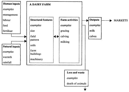
Suppose in the early years at secondary school a group of pupils is working on a half-term unit on the topic of farming. They may have visited a local market garden, and have study material on a Scottish croft, a sample farm in lowland England, a rice-farming area in India, plus some version of a farm game involving decisions with respect to choice of farming activity. The generalisations appropriate to this level concern the operation of a range of natural and human factors influencing the type of agricultural activity found, the farm as a system, the notions that agriculture may be intensive or extensive, or subsistence or commercial in nature. (Refer to Farming, page 15.)

The farmer's inputs and outputs may be listed for the market-garden visited and recorded in diagrammatic form; the same diagram may then be applied to the Scottish croft. The pupils will recognise that both input and output are greater for the market garden; the terms 'intensive' and 'extensive' may be introduced; most pupils will be able to recognise to which type a farm belongs. But their knowledge of the generalisation is rudimentary; faced with examples of a Canadian wheat farm and rice cultivation in the lower Ganges valley, only abler pupils would have achieved enough operational competence to apply the idea accurately. Pupils of modest or lower ability might well, in the new situation, confuse degree of intensity with total output or farm income, and hence pronounce the prairie farm intensive; such pupils will clearly need further experience and


[page 44]

discussion with the teacher in order to establish the idea more clearly.

This, then, raises all the problems of catering for pupils of varying ability, particularly where pupils of this age group are arranged in classes containing a wide spread of ability. It is beyond the scope of this booklet to discuss this question in detail, but again, the identification of general ideas may prove helpful. A common response to this situation is to provide pupils with some form of worksheet through which they can work at their own pace. Such attempts to individualise the learning process can mean that each pupil at a given time has reached a different point in the programme; it follows that most teacher intervention is likely to be with individuals. In an ideas-based teaching syllabus, there are dangers in this situation which need careful watching. A principal aim of any scheme of work based on generalisations must be the enhancement of the pupil's understanding of the material being studied, and acceleration of his progress towards higher order intellectual skills such as analysis and application of the ideas learned and understood. In most cases, this process is facilitated when the teacher, by his sensitive and timely intervention, is able to act as a catalyst; indeed, it is essential for generalisations to be explored and discussed and very difficult for pupils to crystallise and shape ideas without a dialogue which helps them identify what is significant and establishes yardsticks of comparison between different examples. Interaction amongst the pupils and with the teacher is likely to be more fruitful at the small group level, while a measure of class teaching may also be useful for certain aspects of the work. Many of the pupil's written tasks such as recording conclusions and exercises in the application of acquired skills will, of course, be done individually. Any assistance he may require in order to overcome particular problems of expression or understanding will also normally call for individual attention. In short, class, group and individual teaching need to be carefully balanced and steps taken to match the medium with the purpose.

For example, in the case of the farming unit described, a sequence might begin with a short introduction followed by group work on the case study material. Groups of pupils could be working on different studies, with the teacher circulating and trying to draw out the relationships. These could then be reinforced and extended with a class lesson or two, drawing upon the acquired and emerging knowledge of the whole class to develop generalisations and principles. Subsequently the work is differentiated according to ability, abler pupils undertaking exercises designed to apply the principles to new or hypothetical material, less able pupils pursuing further case studies or being taught directly in order to establish a firm understanding of the generalisations. Some of this last phase might also be carried out by pupils working individually, balancing the class and group teaching of earlier episodes.

Clearly, with older pupils, especially those of above average ability pursuing courses leading to examinations at 16-plus, more deductive procedures will be justified. The pupils should already have met the major ideas being manipulated, and will have some background of knowledge and experience to which they can relate statements in abstract form. A fourth-year lesson sequence on the location and


[page 45]

development of the British iron and steel industry might begin by recalling the interrelationship of locational factors depicted in a version of the iron and steel game met during the previous year. These are recalled and discussed at the level of generalisation, actual examples being quoted in context to illustrate a particular point. However, to enable pupils to understand current and proposed changes in the nature and location of the industry, case studies of two or three centres illustrating the contrasting problems, eg Consett, Scunthorpe and Llanwern, are undertaken. These can be used to refine familiar generalisations concerned with locational factors, to introduce more complex ones (especially the impact of government policy), and to highlight some of the implications of the contemporary changes for the settlements involved. Finally the group of generalisations is applied to a study of the current distribution of the industry in Britain, first, to explain its origins, secondly to predict the centres likely to grow, decline and change, and ultimately to compare the pupils' predictions with the approved plans for rationalisation.

Such a sequence consolidates in hypothetical form a given platform of understanding, reverts to a case-study approach to extend and refine the group of generalisations, and finally raises the principles already understood to the level of application; a planned use of inductive and deductive approaches in combination.

Pupils of more modest ability in the same age group will obviously benefit from a more varied range of case-study material based upon small groups of carefully chosen generalisations. If the identification of two or three key ideas of importance is linked initially with the planned introduction and discussion of an appropriate example, pupils can then proceed to apply the understanding required to further case-studies. Such a selective approach seems more likely to produce educational experiences of quality for pupils of modest or low ability, although the danger of a too narrow range of content needs to be averted by a carefully balanced selection of the groups of ideas to be examined.

The foregoing discussion may illustrate how the planning of pupils' learning may be adapted to provide for a wide range of age and ability. Clearly, some of the generalisations are appropriate mainly for older and abler pupils: many, however, are capable of use at an appropriate level of complexity or abstraction in a very wide variety of school situations. No attempt, therefore, has been made to identify any universal sequence in the introduction or development of the ideas articulated.

Syllabus construction

The first and most important purpose of a subject syllabus is to establish a progressive course which gives coherence to successive years of pupils' study in a particular school and, whether taught as a separate subject or as part of a larger curriculum area, geography is no exception to the need for such planning. Once prepared, the syllabus gives direction to the work of a number of teachers but might allow for variety in individual teaching approaches on such aspects as the choice of examples or resources to be used. Such guidance is important in maintaining continuity in teaching, particularly in schools where changes of staff may be frequent. Apart


[page 46]

from the advice to those immediately concerned in teaching a subject a syllabus may also serve the function of informing teachers of other subjects of the main aspects of the work undertaken in the discipline and thereby facilitate co-operative ventures. For example, the geography syllabus may be used by geographers and mathematicians to decide where geographical work using mathematical techniques should be introduced in order to take advantage of previous teaching of the techniques in mathematics. In another ease it may be helpful in identifying the range of language skills and terms used in geography as a contribution to the use of language across the curriculum. Such contacts may help to emphasise broader educational opportunities not initially recognised within a single subject context. Apart from informing the head, who obviously needs to know in detail the work to be undertaken in school, the syllabus is a concise means of indicating to interested visitors to the school the range of work which might be expected to be in progress.

In junior and middle schools it may be the head or a designated teacher who plans and co-ordinates the schemes of work, whereas in secondary schools the responsibility for outlining the structure of a subject syllabus is normally that of the head of department, following consultation with colleagues and taking into account their particular strengths and interests. In those schools choosing to combine subjects within broad curricular areas it is often the practice for teams of teachers to plan the syllabus: where geography is one of the constituent disciplines it would seem self-evident that the planning group should include a geography teacher. Such is not always the case. Once the framework has been established the co-ordinator should initiate discussions with those who will be responsible for teaching the programme. Their delegated task will be that of working, either singly or in small groups, on specific sections within the general outline; this can lead to the development of lesson units exemplifying specific elements of the syllabus. At this stage of planning recently qualified colleagues (and students working temporarily in the school) could play a useful role by introducing recently developed ideas and techniques.

Although the form of one syllabus may vary from that of another, it is desirable for all syllabuses to include a similar range of elements. It is useful for a syllabus to start with a statement of the aims of the course; the general nature of such aims is illustrated by the following examples from the syllabus of an urban comprehensive school.

Some of the aims relating to geography are:

To provide the pupil with geographical information which may be useful in later life. To foster an interest in the study of geography for its own sake.
The aims also include some relating to the general development of the pupil:
To develop the pupil's ability to make and justify judgements.
To foster an element of self-evaluation in each pupil of his or her own performance.
To develop the literacy, numeracy and oracy of each pupil.
And some relating to attitudes:
To develop the pupil's awareness of some of the problems facing mankind, and to encourage an awareness of possible solutions.

[page 47]

To help the pupil become a responsible member of the community through an understanding of the origin, structure and purpose of that community.
To develop the pupil's understanding of agricultural, industrial and commercial considerations,
Aims can serve a dual function; they provide a statement and justification of the place of the subject in the curriculum, and a background of philosophy against which learning experiences may be planned. Of themselves, however, they are of little help in ensuring the provision of educational programmes of quality, unless translated into detailed objectives stating in more precise terms the kinds of pupil knowledge, skills and understanding through which the aims are to be realised.

The generalisations set out in Chapter 3 are not in themselves a syllabus. They contain examples of the ideas which pupils should meet at an appropriate time in their course if they are to understand the work they have undertaken. The generalisations may act initially as a stimulus for teachers so that they may construct for each year a sequence of statements of simpler ideas which when grasped by the pupils will reinforce each other and so form a basis for deeper understanding. In the extracts of syllabuses which follow (pages 49-56) it is possible to identify a variety of ways in which the generalisations or geographical ideas contained in them are used.

The information to be learned needs to be specified. This listing may well be expressed in the context of closely defined objectives as in example F on page 54. There may be a series of statements that: 'The pupils will be able to name the following features on a map ... list the following facts ... demonstrate their recall or use of the following information ...' Some thought should also be given to the selection of an appropriate range and sequence of studies in order that the pupils' learning includes some contact with those aspects of the world which are considered significant. These could be selected to include the pupils' immediate neighbourhood, their home region, the United Kingdom, the EEC, other industrially advanced regions and developing areas of the world. Some knowledge of certain major world distribution patterns may also be considered necessary. Once the selection has been made the details need to be defined and built into the syllabus in terms of specific units of work and the various study areas need to be used to exemplify generalisations. Care should be taken to ensure that the work includes study at a number of different levels as indicated above - local, regional, national, international. The choice of level may depend on the nature of the particular area being studied, the immediacy of the example, the stage of conceptual development of the pupil or factors such as the desirability of developing some background knowledge of a particular area of the world.

Both the ideas and the facts may be outlined within the context of the systematic topics within geography as shown by the lists of generalisations in Part 3; alternatively they may be considered within the context of areas of the world. However, whichever framework is used, it is necessary in a syllabus to be explicit about the elements of the other which are included, For instance, in a syste-


[page 48]

matic study of 'Agriculture' it is desirable to name areas of the world from which examples will be taken, and in a regional study of Australia it is desirable to list the systematic topics to be covered. There are examples of both types of approach in the following section of extracts from syllabuses. Objectives relating to attitudes and values cannot be expressed in the same manner as those concerned with information and ideas.

However, it is important to recognise that, as stated in one syllabus, 'the content of geography is permeated with cultural, social and economic values; the methodology of the subject rests on the value assumption that phenomena may be investigated and explained in a rational manner; the actual teaching strategy adopted expresses the values that what is important is, for example, either the pupil's knowledge or his ability to develop the intellectual skills with which to acquire such knowledge; finally, the very way in which the teacher responds to the pupil and to other members of staff helps to foster certain values.'

The outlining in the syllabus of specific topics for study leads to the recognition that some topics are particularly suited to individual study, some to group study with pupils of either a range of or similar ability and that some demand a situation involving dialogue with a teacher. The range of learning approaches to be used is a useful addition to a syllabus.

The type of working group has a close relationship with the range of study skills to be developed. In the study of geography there are a number of these skills involving the use of a wide range of materials including maps, photographs, statistical representation, written materials, audio-visual materials and, of course, the local environment, and it is helpful if a scheme of work includes a reference to such skills, either linked with the individual units of work where they are to be applied and developed, or in a more general overall statement. There are other intellectual skills more closely integrated with the development and use of the geographical ideas mentioned above. The regularities of patterns and processes can be recognised and drawn out of studies of actual situations, using a variety of source materials and teaching methods to provide a framework for future thought. (See page 41.)

Resources of all types naturally form an important element in implementing the ideas of the syllabus planners. It can be of great assistance in the planning of individual lessons if the availability and location of materials is stated alongside the selected studies. Sometimes shortage or unsuitability of resources is seen as a constraint on the sort of work that can be undertaken; but often other satisfactory ways of working can be devised with careful planning.

Although an assessment of pupils' performance is implicit in any syllabus the decisions on methods of assessment and their timing are better stated explicitly. The results should show the pupils' attainment as well as indicating individual weaknesses in knowledge or skills which can then be remedied. When recorded these assessments should indicate the pupil's achievements and should be available to the next teacher taking on that pupil, whether within the same or at a different school.

A syllabus therefore should include details of general aims,


[page 49]

objectives to be achieved, systematic topics and/or areas of the world to be studied, facts to be learned, ideas to be understood and the attitudes and values to be considered; it should also include details of the skills to be developed, the scale of the units of study, details of the resources available, suggested methods of working and the assessment procedures to be used.

A syllabus is a complex document involving much hard work to formulate, and attention to its format at an early stage can minimise the need to repeat work when amendments become necessary because of changes in approaches to work, changes of staff, the addition of new resources and different areas of the world becoming prominent. If some of the syllabus elements can be kept in separate sections they can be modified with a minimum of restructuring of the whole syllabus. This is particularly important because, although the syllabus is of value in planning a course of work, pupils learn from the experiences provided in the classroom and out of doors, and it is in planning these and participating in this detailed development of the ideas expressed in the syllabus that teachers must inevitably spend much of their time and energy.

Some examples of syllabuses

The examples which follow may help to demonstrate how different schools have approached the construction of schemes of work using generalisations. Each example also illustrates some of the other elements of syllabus planning.

Example A

Teachers in a middle school have developed a scheme of work for 'integrated studies'. For each year group there is a diagram of 'main core from which themes can be selected as desired by year coordinators for development in their year group'. The diagrams are in a familiar style, and a section of that for 10-year-olds is illustrated.


[page 50]

With each diagram there is a list of possible visits in the local area, reference to material from the Schools Council project 'Science 5-13', lists of resources available and detailed suggestions for craft work. These are essential as such diagrams, while valuable for initial planning, need to be followed up in depth if the children's learning that results is to be of a good intellectual level.

Each year-team meets regularly to discuss the programme of work and these teams are organised so that they contain teachers with different interests and abilities. The teacher with particular interest in geography used statements of generalisations. First she examined the work to be covered each year and identified those generalisations which are implicit in the theme outlined in the diagram.

In several cases the formulation of a generalisation suggested new and better ways of looking at a topic. It was possible to consider the ideas connected with the topic and to suggest more difficult aspects for the able children to work on.

The teacher then looked at the overall spread of generalisations and established the range and concentration of the systematic topics such as agriculture or transport covered during the four years. For the first time it became possible to see that considerable emphasis was placed on agriculture and settlement but very little attention was given to manufacturing industries or transport. The imbalance could then be questioned, and the generalisations used as a basis for team discussions on the next sequence of work.

Example B

Two secondary schools were each studying the southern continents during Year 2 of the geography course. Each was working within a regional framework and allocating one term to each of the major southern continents. Teachers in both schools decided to re-plan the term's work on Africa, accepting the constraint that existing regional textbooks would, of necessity, remain the main book-source of information for pupils. The changes they made show significant differences.

i. In the first case the overall aim was specified as 'to promote knowledge and understanding of the relationships between man and the resources at his disposal which have created the distribution of human activity in the present-day world'. Five topics of climate, agriculture, settlement, transport and manufacturing industry were chosen and in a matrix these topics were set against columns in which generalisations and skills were listed. The content of the previous syllabus was considered and checked against the information on the matrix. The matrix was then modified both in order and in substance so as to include the development of the skills and generalisations in the topics.

ii. In the other case the teachers decided to concentrate on the overall theme of 'Population in Africa' and to look at its distribution, at the location of different ethnic groups, at migrations and also at problems associated with the growth of population. A syllabus was drawn up with generalisations


[page 51]

exemplifying these topics and with details of examples to be used in developing the ideas.
In both cases the teachers were pleasantly surprised to see how much use could be made of their old textbooks. In both cases, too, only part of an existing syllabus was modified. The two examples, however, show some clear differences. In the first the main development was to consider more precisely the ideas and skills involved in studying within a broadly traditional regional framework; in the second a more fundamental change in the overall theme was made and less attention was initially paid to skills. Both versions have their strengths in the different circumstances in which they were developed.

Example C

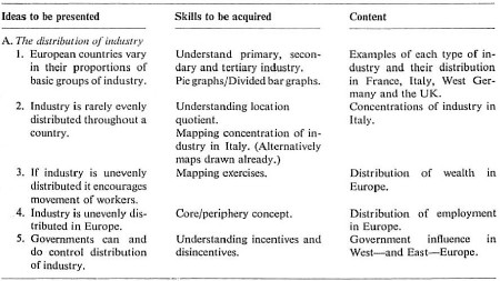
In a comprehensive school generalisations were used in restructuring the whole syllabus. The main themes were chosen and then the generalisations (key ideas) were used to exemplify the aspects of those themes which were to be developed, A small section of Year 1 looks like this:

In this geography syllabus the ideas are developed within the systematic topics; for example, the concept of 'movement' described as 'journeys to work' within 'settlements', is met in the form of 'migration' when looked at within the context of 'population'. Explicit mention of the idea alters the emphasis in teaching and in the assessment made of the pupils' understanding.


[page 52]

Exemplars for the units in this first year of the school course are drawn from the local area, Britain, and the world, though a range of scales of exemplars can be recognised within each of these areas.

This syllabus example does not show all the elements which it has been suggested should be included in a syllabus statement. The detailed use of the 'key ideas', the resources available, the skills to be developed, the methods of working and the form of assessment remain to be specified, although some of these elements are, to the experienced teacher, implicit in the choice of exemplars.

Example D

In another 11-18 school, use of generalisations in studying some topics led to the rewriting of the syllabus and also affected the nature of the tests and assessment units used during the year. So for one half-term of the second year the syllabus reads:

What is industry? Factory as a system.
Factories need raw materials.
Factories need a power supply. (Incorporate coal)
Factories need a good site.
Factories need a labour supply and market.
Managerial decisions are important (simulation) and paramount orienting factors as part of a test.
An earlier farm study involved a systems approach and this method was developed further in the study of an industry. Five of the factors affecting location of manufacturing industry are looked at in detail and the titles quoted above are the headings of worksheets in which each idea is developed and extended with a variety of examples. Films and tapes were also used in developing these ideas and for the simulation the pupils worked in groups. Some methods of working are implied in the syllabus but the full range of pupil groupings, resources and skills are not indicated. The test was a unit of work devised to assess the levels at which pupils understood the ideas studied during the half-term. It was given to all classes, even if elements of the previous work had varied; it was carefully structured to establish the degree of basic understanding of the ideas and to permit some pupils to demonstrate their greater ability to generalise and compare.

Although this example illustrates the order in which a department set about improving the quality of work the syllabus will be an even more useful document when details such as resources, skills, scale of examples and areas of study have been added.

Example E

Teachers in another school which was to be reorganised as a comprehensive school saw this as an opportunity to recast the geography syllabus and bring it more into line with recent trends in the subject. They decided to proceed cautiously and, in the first instance, to re-structure the work of Years 1 and 2 only. For the first-year syllabus four general aims were agreed upon, a list of more specific


[page 53]

objectives was then made and then five half-term units of work decided upon. These units were 'Home and school', 'Small settlements', 'Large settlements', 'Industry' and 'Farming'. Each unit was developed using a matrix as shown.

YEAR 1

The syllabus for the second year was approached rather differently as, although the same framework of headings was used, the work for this year was based on newly acquired textbooks. A section from this second-year syllabus follows:

YEAR 2 European patterns


[page 54]

The planning of this syllabus began with the identification of general ideas grouped under systematic headings; content examples have then been selected which offer significant illustrations of the operation and interaction of the principles identified. In such a planning exercise the task is complicated by the associated need to ensure that the completed syllabus is more than a collection of units but covers a range of content which provides pupils with a sound basis of geographical knowledge. In this case, for example first-year topics are chosen entirely from the local area and the United Kingdom, while the second year includes studies of other developed nations in Western Europe. It is interesting to note that in planning how to assess pupils' progress, the assessment of 'skills to be acquired' tends to be easier than determining the information pupils should be able to recall.

Example F

A syllabus from another comprehensive school geography department is of particular interest because of the importance placed on objectives in its drafting. The third-year scheme of work for pupils in the upper band on 'Selected studies from the USA' is introduced by some general aims and an outline of the course in which six regions are listed and the main points of geographical significance to be stressed are briefly noted. Each of these regions is then examined under the headings of aims, objectives and resources, as Unit 3 shows.

Unit Three - North Dakota

Aims

1. To show significant aspects of the human geography of a rural, thinly-populated area of the US agricultural interior.
2. To show the problems of living in a vast landscape under extreme climatic conditions.
3. To show the organisation of extensive commercial grain farming.
4. To show the effects of rural depopulation on agricultural areas.
5. To show the cycle of settlement, cultivation and desertion.

Objectives

Seventeen terminal objectives are listed for this unit. Among these the pupil is expected to be able to:

2. Outline the Great Plains on a map of the USA.
4. Locate the state of North Dakota on a map of the Great Plains.
5. Describe the landscape of North Dakota.
6. Describe the main features of a continental climate.
8. Use a climatic graph to calculate:

annual temperature range
average monthly temperature
total annual rainfall.
12. Relate the physical environment of North Dakota to the conditions necessary for the growing of wheat.
15. Explain the increasing rural depopulation of North Dakota.


[page 55]

17. Suggest (in a simulated situation) a solution to a simple logistical problem typical of the Great Plains, eg a new bus route.
(Eight other objectives are listed.)

Resources

A. Slide set, The Great Plains/Wheat.
B. OP transparencies: The Great Plains, Langdon, North Dakota, climatic graphs.
C. Duplicated materials:

map - The Great Plains
worksheet - North Dakota
simulation game - a new bus route
test item III.
D. Videotape - North Dakota.
E. Textbooks BBC - USA '72, pages 8-11 etc. (Others are listed.)

This is a good example of a syllabus where the initial emphasis was on content selection; once the areas to be studied had been defined the identification of general ideas helped to select and focus attention upon significant aspects of the study. In such an approach it is also important to ensure that the relationships, patterns and processes which are emphasised in this section of the scheme of work are significant enough to assist pupils in understanding other areas of the world.

Example G

An education officer decided to encourage the development of a humanities course for pupils between the ages of 8 and 13 years. It was intended to produce a handbook and then to develop units of work which would be available to teachers from the curriculum resources centre. Groups of subject-teachers, already well established, were asked to outline the main aspects of their subjects which should be included in the overall scheme. The geographers identified the main considerations as: (i) basic ideas, (ii) systematic topics, (iii) scale of examples and world coverage, (iv) skills.

The basic ideas were concerned with location in terms of points, lines and areas and with the processes which influence such locations and so give rise to spatial patterns. Account would also be taken of chance factors. Study of the basic ideas would be in the context of the systematic topics treated at a variety of scales and with a view to the acquisition of specified skills. Quotations from the original document follow:

BASIC IDEAS
'Location' and 'links' are the two basic ideas in geography. Location can be thought of in terms of points, lines and areas; examples of these might be settlements, roads and industrial regions. By links we mean the processes which influence locations - the factors which affect spatial patterns. Locations and links can be looked at on a variety of scales. Equally important is the element of chance in patterns and processes. These basic ideas can be studied within the context of any systematic topics in geography.

[page 56]

SYSTEMATIC TOPICS
By the age of 13 a pupil should have studied some aspects and have gained an understanding of key ideas in each of the following topics: settlement, physical environment, agriculture, manufacturing industry. (About 10 major generalisations were then listed for each of these topics.)

There are other systematic topics which might also feature to some degree in a child's studies, These include:

i. Population - main aspects are distribution, classification, migration and change. These are looked at in more detail in the section on social studies in this document.
ii. Transport. For example, modes of transport, changes, networks.

SCALE AND WORLD COVERAGE
Children should study these ideas by looking at examples on a number of different scales: the small locality, the national scale, continental scale and world scale. Where possible, the local environment should be the starting point.

In addition the examples should be drawn from a variety of areas, such as the British Isles and the rest of the EEC, other developed regions, the developing nations of Africa, Asia or Latin America.

SKILLS
Children will develop a great variety of skills in studying geography. Many of these have been outlined on an earlier page since they apply equally in other disciplines. The map skills listed below are particularly characteristic of geographical studies.

There followed a list of skills involved in using maps written in a form that children should (a) appreciate that ... and (b) be able to ...

In this example the choice of a systematic approach to geography was influenced partly by the desire to facilitate the links with other subjects within the general area of humanities. It is significant that the officer coordinating the scheme wished to provide guidelines rather than a unified course for all schools and envisaged that schools might choose to study humanities either as an integrated area or as separate subjects. Giving each subject the space for its ideas and skills and topics to be outlined enables this choice to be made on a firm foundation. It is also important to notice that the detailed units of work were to be developed from the careful planning outlined here. Whether these units are used in geography taught separately, or within an integrated course, the required structure and quality of the work are clear. The scheme provides a sound basis for those children in the area who transfer between schools at 13 and move into specialist study, and recognises, too, that the school has a responsibility to plan a course which is wide-ranging in terms of the geographical ideas studied since for many pupils this will be most, if not the whole, of their geographical education.


[page 57]

Appendix


Mapwork

These statements should be seen as a set of goals for pupils to work towards. Each area of mapwork is introduced by a general instructional objective amplified by a series of more specific statements the order of which does not suggest a particular sequence in learning.

A. Appreciate maps as a shorthand representation of an area involving visual expression in place of complex narrative.

1. Study maps as sources of interest as well as information.
2. Select maps as a means of communication.
3. Organise information to be clearly displayed on maps.
4. Identify maps as useful investigatory tools.
5. Modify ideas based on map evidence in the light of additional information.
B. Understand the problem of representing the curved earth's surface on a flat sheet of paper.
1. Demonstrate practically that a spherical surface, such as that of the globe has to be stretched in order to represent it on a flat surface.
2. Show that the stretching can take place in any direction.
3. Compare with their counterparts on the globe the distances, directions, shapes and areas of land masses and oceans which result from the differences in stretching.
4. Detect that distortion increases with the size of the area.
C. Know that the degree of generalisation used in map-making increases with the decreasing scale of maps.
1. Draw and label symbols used on small-scale OS maps.
2. Compile a key (or legend) to illustrate classified or grouped information in a map.
3. Identify items or categories of land use and geology on atlas maps from the key (or legend) provided.
4. Reproduce symbols to represent on a sketch map, point, line and surface features on the ground.
5. Identify the range of information available on a map.
6. List other information which, if mapped, would help in the investigation of given problems.
7. Verify that some symbols on small-scale maps are disproportionate to their real size,
D. Use co-ordinates to locate places on maps.
1. Plot locations from grid references or by latitude and longitude.
2. State grid references or the latitude and longitude of given locations,
3. Search a gazetteer as a guide to locations.

[page 58]

E. Understand the purpose of the alternative statements of scale.

1. Identify the amount of magnification or reduction of compared maps of an area using the representative fraction, eg 1:25000 compared with 1:100 000).
2. Measure, using maps of progressively smaller scales, the straight line distance between two points correct to the nearest quarter mile (quarter kilometre).
3. Measure, using maps of progressively smaller scales, distances along winding routes with a tolerance of half a mile (half kilometre) above or below the correct distance.
4. Estimate, using progressively smaller scales, distances on a map to the nearest half mile (half kilometre).
5. Estimate distances on the ground within a 25 per cent margin of error.
F. Know the values and limitations of topological maps.
1. Simplify a route map topologically.
2. Extract information from topological maps.
3. Transform a distance-scale map into one based on time or cost.
G. Perform the alternative methods of determining direction.
1. Plot the cardinal points of the compass.
2. Find directions and bearings using a simple prismatic compass.
3. Orientate a map using a simple prismatic compass.
4. Verify a position by re-section using a simple prismatic compass.
5. Describe a route from a map using directions and estimated distances.
6. Follow a route on a map (or on the ground using a map) from a statement giving directions and estimated distances.
7. Orientate a large-scale plan (1:2500) using surrounding buildings as reference points.
8. Relate one's position on the ground to a location on a large-scale plan, eg 1:2500 or 1:10 000.
H. Interpret general and precise ways of showing height above sea level on maps.
1. Isolate highland from lowland shown on a map.
2. Generalise about the height of land in a given area.
3. Describe the nature of selected slopes in terms of gentle, steep, even, concave or convex.
4. Identify the overall shape of a landscape and add descriptions of more detailed features within it.
5. Distinguish between spurs and valleys.
6. Draw sketch sections and accurate sections from prepared material or from large-scale maps (minimum scale 1:25 000).
7. Identify simple relief features from cross-section shapes.
8. Compute an average gradient between fixed points.
9. Determine diagrammatically whether one point is visible from another and shade the extent of 'dead ground'.

[page 59]

I. Demonstrate the drainage patterns of an area.

1. Subdivide an area into drainage basins.
2. Discriminate between streams and rivers.
3. Infer the location of a spring line.
4. Outline the main directions of drainage.
5. Compute a density of drainage within basins.
J. Interpret patterns of point, line and surface features. In relation to relief and drainage.
1. Generalise on the location, extent and distribution of settlements and vegetation.
2. Separate patterns of communication in an area in terms of type, directions and densities.
3. Infer human activity from direct map evidence. (NB. Beware of the danger of enforced interpretation without supporting evidence.)
K. Use special-purpose maps (those using or based on statistics) as sources and stores of information.
1. Extract information from special-purpose maps.
2. Generalise about distributions from these maps.
3. Sample information from these maps.
4. Relate distributions of physical phenomena shown on two maps, eg rainfall amount and relief.
5. Select the appropriate method to illustrate simple statistical information on a map, eg dot maps, choropleth maps, isoline maps, maps with pictorial symbols, bar graphs and histograms.
6. Distinguish between maps which give quantitative and non-quantitative statements.
7a. Translate the divisions on quantitative maps as transition zones.
7b. Translate quantitative maps as indicators of trends and regional patterns as well as providing comparative values at particular points.
L. Analyse weather conditions from synoptic charts of the British Isles.
1. Infer weather conditions in various parts of the British Isles given a map showing either a simple depression or an occlusion or an anti-cyclone affecting the region.
2. Construct an isobar map given pressure details of 20 weather stations over the British Isles and North Atlantic.
3. Indicate the location of a simple frontal system on this map given additional details of temperature, cloud and rainfall conditions at those 20 stations.
M. Make maps to illustrate spatial information.
1. Edit information into a sketch map.
2. Construct simple topographical maps from a narrative using accepted symbols, eg from the 1 in, 2½ in or 1:50 000 OS maps.

[page 60]

3a. Draw from memory a labelled map of a small, well-known area showing estimated distances and directions.
3b. Compare this map with a plan of the locality.
4. Survey a small, irregularly shaped area using compass traverse, chain survey and/or home-made clinometer procedures.

Create maps freely.
1. Draw maps of imaginary areas or from stories etc, in the manner, say, of Tolkien's Middle-earth, Stevenson's Treasure Island; maps of 'my island', 'my secret valley', 'the second moon' etc.

2. Make maps with symbols as a means to develop language.

N. Visualise a landscape using photographs alongside a map.
1. Describe a scene with the combined evidence of oblique photographs and map.
2. Amplify map evidence from stereoscopic pairs of air photographs.
3. Identify the limitations of the bird's-eye view of a map compared with the information available from an oblique photograph.